IMAGES TAKEN NEAR TO
Upton Lane, GLOUCESTER, GL4 0UT
Introduction
This page details the photographs taken nearby to Upton Lane, GL4 0UT by members of the Geograph project.
The Geograph project started in 2005 with the aim of publishing, organising and preserving representative images for every square kilometre of Great Britain, Ireland and the Isle of Man.

There are currently over 7.5m images from over14,400 individuals and you can help contribute to the project by visiting https://www.geograph.org.uk
Image Map
Images are licensed for reuse under creativecommons.org/licenses/by-sa/2.0
Notes
- Clicking on the map will re-center to the selected point.
- The higher the marker number, the further away the image location is from the centre of the postcode.
Image Listing (7 Images Found)
Images are licensed for reuse under creativecommons.org/licenses/by-sa/2.0
Image
Details
Distance
1
Cottage, Brentlands, Upton Lane, Brookthorpe
Looking towards Brookthorpe and the main road to Stroud.
Image: © Colin Manton
Taken: 24 Jul 2011
0.02 miles
2
Upton Lane, Brookthorpe
Post Box Upton Lane, Brookthorpe
Image: © Colin Manton
Taken: 24 Jul 2011
0.05 miles
3
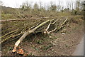
A laid hedge at Brookthorpe
Given the thickness of some of the trunks in this hedge, laying it must have been quite challenging.
Image: © Philip Halling
Taken: 23 Feb 2013
0.18 miles
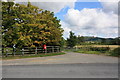
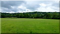
4
Farmland at Brookthorpe
Farmland below the Cotswold escarpment at Brookthorpe.
Image: © Philip Halling
Taken: 2 Mar 2013
0.19 miles
5
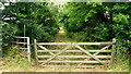
Green Lane
Leading west from Upton Lane, Brookthorpe.
Image: © Jonathan Billinger
Taken: 5 Aug 2013
0.23 miles
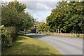
6
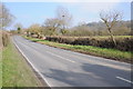
Country road near Brookthorpe
Country road near Grange Farm, Brookthorpe.
Image: © Philip Halling
Taken: 2 Mar 2013
0.23 miles
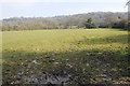
7
Pasture below the Cotswold Scarp
The view east from Upton Lane near Ongers Farm.
Image: © Jonathan Billinger
Taken: 5 Aug 2013
0.24 miles