IMAGES TAKEN NEAR TO
Andrews Close, GLOUCESTER, GL4 0UR
Introduction
This page details the photographs taken nearby to Andrews Close, GL4 0UR by members of the Geograph project.
The Geograph project started in 2005 with the aim of publishing, organising and preserving representative images for every square kilometre of Great Britain, Ireland and the Isle of Man.

There are currently over 7.5m images from over14,400 individuals and you can help contribute to the project by visiting https://www.geograph.org.uk
Image Map
Images are licensed for reuse under creativecommons.org/licenses/by-sa/2.0
Notes
- Clicking on the map will re-center to the selected point.
- The higher the marker number, the further away the image location is from the centre of the postcode.
Image Listing (70 Images Found)
Images are licensed for reuse under creativecommons.org/licenses/by-sa/2.0
Image
Details
Distance
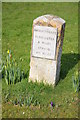
1
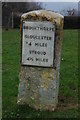
Milestone at Brookthorpe
Milestone at Brookthorpe indicating 4 miles to Gloucester and 4 1/2 to Stroud.
Image: © Philip Halling
Taken: 10 Jan 2009
0.01 miles
2
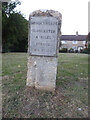
Old Milestone, Brookthorpe
Opposite Fagin's pub (formerly the "Four Mile House"). Set back from the layby/bus stop.
Inscription: Brookthorpe / Gloucester / 4 Miles / Stroud / 4½ Miles
Milestone Society National ID: GL_GLSD04
Image: © Mr Red
Taken: 23 Sep 2021
0.02 miles
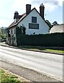
3
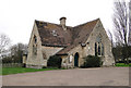
Village Hall, Brookthorpe
Former school, probably. Architect not known, but they had no hand in designing the crazy notice board, surely. In use virtually every day.
Image: © Philip Pankhurst
Taken: 6 Apr 2010
0.02 miles
4
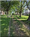
Public footpath between trees, Brookthorpe
From the A4173, the main road through Brookthorpe.
Image: © Jaggery
Taken: 24 Apr 2022
0.02 miles
6
Public footpath direction sign, Brookthorpe
The sign near the A4173 points towards this https://www.geograph.org.uk/photo/7157023 path.
Fagin's restaurant is in the background.
Image: © Jaggery
Taken: 24 Apr 2022
0.03 miles
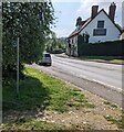
7
A4173, Brookthorpe
Looking south along the main street.
The road climbs out of the village onto the Cotswold scarp towards Stroud.
Image: © Jonathan Billinger
Taken: 5 Aug 2013
0.03 miles
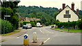
8
Fagin's, Stroud Road, Brookthorpe, Gloucestershire
Restaurant viewed across the A4173.
Image: © Jaggery
Taken: 24 Apr 2022
0.03 miles
9
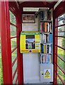
Inside a former red phonebox, Brookthorpe, Gloucestershire
In April 2022 a defibrillator box and a small library of books are inside this https://www.geograph.org.uk/photo/7156286 red box.
Image: © Jaggery
Taken: 24 Apr 2022
0.03 miles
10
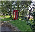
Red box, Brookthorpe, Gloucestershire
In April 2022 the former red phonebox near the village hall has two new uses. It houses a defibrillator box and a small library of books. https://www.geograph.org.uk/photo/7156292
Image: © Jaggery
Taken: 24 Apr 2022
0.03 miles