IMAGES TAKEN NEAR TO
Sandford Way, GLOUCESTER, GL4 0TR
Introduction
This page details the photographs taken nearby to Sandford Way, GL4 0TR by members of the Geograph project.
The Geograph project started in 2005 with the aim of publishing, organising and preserving representative images for every square kilometre of Great Britain, Ireland and the Isle of Man.

There are currently over 7.5m images from over14,400 individuals and you can help contribute to the project by visiting https://www.geograph.org.uk
Image Map
Images are licensed for reuse under creativecommons.org/licenses/by-sa/2.0
Notes
- Clicking on the map will re-center to the selected point.
- The higher the marker number, the further away the image location is from the centre of the postcode.
Image Listing (7 Images Found)
Images are licensed for reuse under creativecommons.org/licenses/by-sa/2.0
Image
Details
Distance
1

Daniel's Brook
This flows north between the housing estates of Lower Tuffley and the new housing at Quedgeley.
Image: © Jonathan Billinger
Taken: 8 Jul 2009
0.15 miles
2
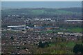
Gloucester : Tuffley - City Scenery
Looking across the suburbs from Robinswood Hill.
Image: © Lewis Clarke
Taken: 2 Apr 2023
0.17 miles
3
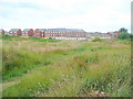
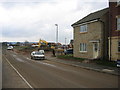
Gloucester expands!
New housing on land west of Daniel's Brook viewed from the footpath from Bodiam Avenue, Lower Tuffley.
Image: © Jonathan Billinger
Taken: 8 Jul 2009
0.18 miles
5
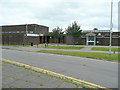
View to Beaufort Community School, Lower Tuffley
This large comprehensive school serves the southern suburbs of Gloucester and takes in 1200 students. The buildings, like most of Lower Tuffley's housing, dates back to the early 1970's.
Image: © Jonathan Billinger
Taken: 8 Jul 2009
0.23 miles
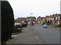
6
Tuffley Community Centre and Library
Off Windsor Drive, Lower Tuffley.
Image: © Jonathan Billinger
Taken: 8 Jul 2009
0.25 miles
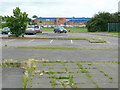
7
New housing, RAF Quedgeley
View south from the northern reaches of this ex military depot, rapidly disappearing under new housing
Image: © Peter Watkins
Taken: 21 Feb 2006
0.25 miles