IMAGES TAKEN NEAR TO
Ryelands, GLOUCESTER, GL4 0QA
Introduction
This page details the photographs taken nearby to Ryelands, GL4 0QA by members of the Geograph project.
The Geograph project started in 2005 with the aim of publishing, organising and preserving representative images for every square kilometre of Great Britain, Ireland and the Isle of Man.

There are currently over 7.5m images from over14,400 individuals and you can help contribute to the project by visiting https://www.geograph.org.uk
Image Map
Images are licensed for reuse under creativecommons.org/licenses/by-sa/2.0
Notes
- Clicking on the map will re-center to the selected point.
- The higher the marker number, the further away the image location is from the centre of the postcode.
Image Listing (4 Images Found)
Images are licensed for reuse under creativecommons.org/licenses/by-sa/2.0
Image
Details
Distance
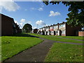
2
Estate shops, Lower Tuffley
Shops, with flats above, in Windsor Drive on the southern outskirts of Gloucester.
Image: © Jonathan Billinger
Taken: 8 Jul 2009
0.23 miles

4
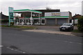
Former Grange Motors, Tuffley
Another closed independent garage, this one is Grange Motors on Grange Road in Tuffley.
Image: © Philip Halling
Taken: 16 Feb 2013
0.25 miles