IMAGES TAKEN NEAR TO
Southern Avenue, GLOUCESTER, GL4 0AA
Introduction
This page details the photographs taken nearby to Southern Avenue, GL4 0AA by members of the Geograph project.
The Geograph project started in 2005 with the aim of publishing, organising and preserving representative images for every square kilometre of Great Britain, Ireland and the Isle of Man.

There are currently over 7.5m images from over14,400 individuals and you can help contribute to the project by visiting https://www.geograph.org.uk
Image Map
Images are licensed for reuse under creativecommons.org/licenses/by-sa/2.0
Notes
- Clicking on the map will re-center to the selected point.
- The higher the marker number, the further away the image location is from the centre of the postcode.
Image Listing (19 Images Found)
Images are licensed for reuse under creativecommons.org/licenses/by-sa/2.0
Image
Details
Distance
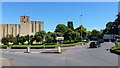
1
St Barnabas's Church, Gloucester
By the roundabout at the junction of Stroud Road and Cole Avenue.
Image: © David Stowell
Taken: 18 Sep 2005
0.00 miles
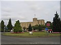
3
St. Barnabas' church, Gloucester
At the busy intersection of the Stroud Road and the A38 ring road.
The striking building in pale coloured materials is late-art-deco period 1938-40.
Image: © Jonathan Billinger
Taken: 10 Aug 2012
0.05 miles
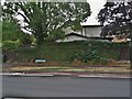
5
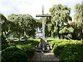
War Memorial, Tuffley
Commemorates the fallen of the Second World War https://historicengland.org.uk/listing/the-list/list-entry/1420087?section=official-list-entry
Image: © Jonathan Thacker
Taken: 3 Oct 2023
0.08 miles
6
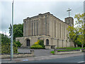
St Barnabas, Stroud Road, Gloucester
By N.F. Cachemaille-Day, 1938-40, "the best interwar church in the county". Grade II* listed.
Image: © Stephen Richards
Taken: 19 May 2015
0.08 miles
7
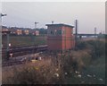
Tuffley Junction signal box
A slightly indistinct view of the signal box whose remains can be seen in Image This was before the box was replaced by the new Gloucester Power Box. At this point there were 4 main line tracks. The furthest two, signalled with lower quadrant signals, were the former GWR lines from Gloucester Central to Swindon whilst the nearer two, signalled with upper quadrant signals, were the ex-Midland Railway route from Birmingham to Bristol via Gloucester Eastgate. The two sets of lines ran parallel as far a Standish junction and were operated a more or less independent railways! With the resignalling and track rationalisation this stretch was reduced to 2 tracks when the signal boxes closed.
The signal box itself was a WWII era structure. Notice also the large telegraph pole routes, one on each side of the tracks, carrying the signalling and telephone circuits.
Image: © David Stowell
Taken: 10 Aug 1968
0.08 miles
8
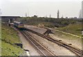
Tuffley Junction
Looking south towards the bridge from which Image was taken. The line diverging to the right ran parallel to the main line as far as Quedegely serving the MoD and the former Dowmac concrete works just north of Naas Lane. The brick base of the former Tuffley Junction signal box can be seen to its right and the cutting just visible to the right of that was the former loop line to Gloucester Docks, with a spur which served Gloucester gasworks alongside the Bristol Road until the 1960s.
Image: © David Stowell
Taken: Unknown
0.08 miles
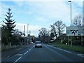
9
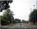
Stroud Road, Tuffley
The A4173, heading out of Gloucester on the Stroud Road. The road to the left is Oakbank.
Image: © Peter Kazmierczak
Taken: 11 Aug 2012
0.09 miles
10
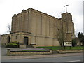
St Barnabas church
St Barnabas church was built in 1938-40 and is described by Pevsner as 'the best interwar church in the county'.
Image: © Philip Halling
Taken: 20 Mar 2010
0.10 miles