IMAGES TAKEN NEAR TO
Cleveland Drive, GLOUCESTER, GL3 4SH
Introduction
This page details the photographs taken nearby to Cleveland Drive, GL3 4SH by members of the Geograph project.
The Geograph project started in 2005 with the aim of publishing, organising and preserving representative images for every square kilometre of Great Britain, Ireland and the Isle of Man.

There are currently over 7.5m images from over14,400 individuals and you can help contribute to the project by visiting https://www.geograph.org.uk
Image Map
Images are licensed for reuse under creativecommons.org/licenses/by-sa/2.0
Notes
- Clicking on the map will re-center to the selected point.
- The higher the marker number, the further away the image location is from the centre of the postcode.
Image Listing (6 Images Found)
Images are licensed for reuse under creativecommons.org/licenses/by-sa/2.0
Image
Details
Distance
1
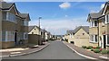
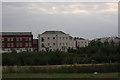
Viceroy Close, Brockworth
A modern housing estate on the eastern edge of Gloucester.
Image: © Jonathan Billinger
Taken: 8 May 2020
0.14 miles
2
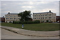
Unknown Road, New Estate, Coopers Edge,
Coopers Edge, Brockworth, Gloucester
Image: © Colin Manton
Taken: 27 Jul 2011
0.15 miles
3
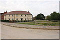
Unnamed Road, Coopers Edge, Gloucester
Coopers Edge, Gloucester - New Development
Image: © Colin Manton
Taken: 27 Jul 2011
0.17 miles
4
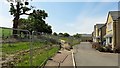
Edge of suburbia
Modern housing encroaches on open countryside near Brockworth.
Image: © Jonathan Billinger
Taken: 8 May 2020
0.17 miles
5
Beamont Walk, Apartments
Beamont Walk, Coopers Edge, Brockworth. Many of the roads were named after world war 2 pilots and aircraft as the estate is built on a former airfield.
Image: © Colin Manton
Taken: 27 Jul 2011
0.22 miles
6
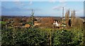
View over Abbotswood Farm
Taken from its Christmas Tree plantation looking over the top of the farmhouse to the city of Gloucester and the hills beyond.
Image: © Rob Farrow
Taken: 8 Dec 2019
0.23 miles