IMAGES TAKEN NEAR TO
Abbotswood Road, GLOUCESTER, GL3 4NZ
Introduction
This page details the photographs taken nearby to Abbotswood Road, GL3 4NZ by members of the Geograph project.
The Geograph project started in 2005 with the aim of publishing, organising and preserving representative images for every square kilometre of Great Britain, Ireland and the Isle of Man.

There are currently over 7.5m images from over14,400 individuals and you can help contribute to the project by visiting https://www.geograph.org.uk
Image Map (7 Images)


Leaflet Map data © OpenStreetMap
Images are licensed for reuse under creativecommons.org/licenses/by-sa/2.0
Notes
- Clicking on the map will re-center to the selected point.
- The higher the marker number, the further away the image location is from the centre of the postcode.
Image Listing (7 Images Found)
Images are licensed for reuse under creativecommons.org/licenses/by-sa/2.0
Image
Details
Distance
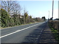
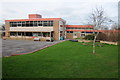
1
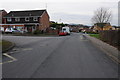
Abbotswood Road, Brockworth
Abbotswood Road near Castle Hill primary School in Brockworth.
Image: © Philip Halling
Taken: 5 Jan 2013
0.12 miles
2
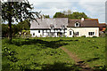
Watermead Cottages
Another view of these picturesque cottages on the edge of Brockworth.
Image: © Mike Baldwin
Taken: 1 May 2009
0.13 miles
3
Castle Hill Primary School, Brockworth
Image: © Philip Halling
Taken: 5 Jan 2013
0.14 miles
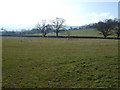
4
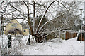
Snow Scene, Watermead, Brockworth
This was taken on an alleyway leading from 132 Abbotswood Road to Watermead. The cottages on the left include a lovely tudor half-timbered one for which I have submitted a separate photograph taken at a different time of the year.
Image: © Mike Baldwin
Taken: 8 Feb 2007
0.16 miles
5
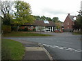
Brockworth Surgery
On Abbotswood Road, http://www.brockworthsurgery.nhs.uk/
Image: © Mike Faherty
Taken: 16 Oct 2009
0.18 miles