IMAGES TAKEN NEAR TO
Guise Avenue, GLOUCESTER, GL3 4NA
Introduction
This page details the photographs taken nearby to Guise Avenue, GL3 4NA by members of the Geograph project.
The Geograph project started in 2005 with the aim of publishing, organising and preserving representative images for every square kilometre of Great Britain, Ireland and the Isle of Man.

There are currently over 7.5m images from over14,400 individuals and you can help contribute to the project by visiting https://www.geograph.org.uk
Image Map
Images are licensed for reuse under creativecommons.org/licenses/by-sa/2.0
Notes
- Clicking on the map will re-center to the selected point.
- The higher the marker number, the further away the image location is from the centre of the postcode.
Image Listing (16 Images Found)
Images are licensed for reuse under creativecommons.org/licenses/by-sa/2.0
Image
Details
Distance
1

Castle Hill Primary School, Brockworth
Image: © Philip Halling
Taken: 5 Jan 2013
0.11 miles
2
Bus shelter, Painswick Road (A46), Brockworth
Image: © David Smith
Taken: 29 Dec 2017
0.12 miles
3
Abbotswood Road, Brockworth
Abbotswood Road near Castle Hill primary School in Brockworth.
Image: © Philip Halling
Taken: 5 Jan 2013
0.15 miles
6
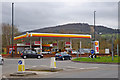
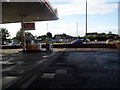
Shell Filling Station, Brockworth, Gloucester
This filling station is off the roundabout on the A46 road, by the Cross Hands pub. The roundabout, part of which can be seen here, is built on part of the site of the original pub, which was demolished in the late 1930's, to facilitate road widening.
Image: © P L Chadwick
Taken: 11 Mar 2011
0.16 miles
7
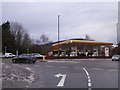
Petrol station on the Crosslands Roundabout, Brockworth
Image: © David Howard
Taken: 28 Jul 2018
0.17 miles
9
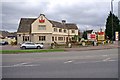
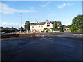
Cross Hands (1), Shurdington Road, Brockworth, Gloucester
Built in 1937 by the former Stroud Brewery Company, on land behind the former pub of the same name, which was required for road widening. The adjacent roundabout is on part of the original pub's site. That pub had existed from at least 1856, when the Landlord is recorded as Richard Organ. At that time it had its own brewhouse. Part of the roubndabout can be seen in this view:- Image
Today, after various changes of ownership, it is one of the chain of pubs branded as a "Toby Pub & Carvery". It just about retains its original name, which can be seen on a board outside, but the strong emphasis is on the Toby branding. The Toby chain are owned by Mitchells & Butlers, and are food focussed. M & B used to be a well known Midlands brewery, but they have retreated from that, to concentrate on pub ownership, and their many brands, of which "Toby" is one.
Image
Image: © P L Chadwick
Taken: 11 Mar 2011
0.19 miles