IMAGES TAKEN NEAR TO
Ermin Park, GLOUCESTER, GL3 4DP
Introduction
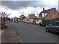
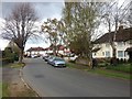
This page details the photographs taken nearby to Ermin Park, GL3 4DP by members of the Geograph project.
The Geograph project started in 2005 with the aim of publishing, organising and preserving representative images for every square kilometre of Great Britain, Ireland and the Isle of Man.

There are currently over 7.5m images from over14,400 individuals and you can help contribute to the project by visiting https://www.geograph.org.uk
Image Map (Loading...)


Getting Data...Please wait
Leaflet Map data © OpenStreetMap
Images are licensed for reuse under creativecommons.org/licenses/by-sa/2.0
Notes
- Clicking on the map will re-center to the selected point.
- The higher the marker number, the further away the image location is from the centre of the postcode.
Image Listing (9 Images Found)
Images are licensed for reuse under creativecommons.org/licenses/by-sa/2.0
Image
Details
Distance
6
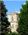
The tower of St George's Church, Brockworth
As a result of the restoration of St George's Church in about 1846, the tower height was doubled and a new ringing room was created for the bells. Previously to this the bells had been rung from ground level in the centre of the church.
Image: © Sharon Loxton
Taken: 26 Sep 2007
0.24 miles
7
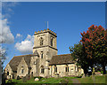
St George's Church, Brockworth.
St George's Church was built by the first resident Norman - Lord of the Manor, Roger de Chandos. In 1142 it was consecrated and became one of the earliest churches in England to be dedicated to St George. In about 1846 the church was renovated at a cost of around £800.
The settlement of Brockworth dates from Saxon times (600AD) when it was named "Brocwurthin" - the "wurthin" (enclosure) by the "broc" (brook).
Image: © Sharon Loxton
Taken: 26 Sep 2007
0.24 miles