IMAGES TAKEN NEAR TO
Golf Club Lane, GLOUCESTER, GL3 4AJ
Introduction
This page details the photographs taken nearby to Golf Club Lane, GL3 4AJ by members of the Geograph project.
The Geograph project started in 2005 with the aim of publishing, organising and preserving representative images for every square kilometre of Great Britain, Ireland and the Isle of Man.

There are currently over 7.5m images from over14,400 individuals and you can help contribute to the project by visiting https://www.geograph.org.uk
Image Map (Loading...)


Getting Data...Please wait
Leaflet Map data © OpenStreetMap
Images are licensed for reuse under creativecommons.org/licenses/by-sa/2.0
Notes
- Clicking on the map will re-center to the selected point.
- The higher the marker number, the further away the image location is from the centre of the postcode.
Image Listing (4 Images Found)
Images are licensed for reuse under creativecommons.org/licenses/by-sa/2.0
Image
Details
Distance
1
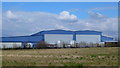
Industrial buildings, Gloucester Business Park, 1
View north from Hurricane Road.
Image: © Jonathan Billinger
Taken: 30 Mar 2013
0.05 miles
2
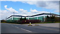
Industrial buildings, Gloucester Business Park, 2
Just as anonymous as Image
Image: © Jonathan Billinger
Taken: 30 Mar 2013
0.12 miles
3

Churchdown Hill From Handley Park, Brockworth
View towards Churchdown Hill, with Malvern Hills in the far distance.
Image: © Colin Manton
Taken: 17 Aug 2021
0.19 miles
4
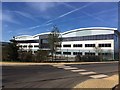
Site of New Dowty Propeller Factory
GE Dowty (Dowty Propellers), Hurricane Road, Brockworth Business Park, Gloucester. This factory replaces the factory that burnt down at Staverton, Gloucestershire.Nearing completion it is assumed that it will be occupied prior to December 2019.
Image: © Colin Manton
Taken: 13 Sep 2019
0.22 miles