IMAGES TAKEN NEAR TO
Simmonds Road, GLOUCESTER, GL3 3JB
Introduction
This page details the photographs taken nearby to Simmonds Road, GL3 3JB by members of the Geograph project.
The Geograph project started in 2005 with the aim of publishing, organising and preserving representative images for every square kilometre of Great Britain, Ireland and the Isle of Man.

There are currently over 7.5m images from over14,400 individuals and you can help contribute to the project by visiting https://www.geograph.org.uk
Image Map (Loading...)


Getting Data...Please wait
Leaflet Map data © OpenStreetMap
Images are licensed for reuse under creativecommons.org/licenses/by-sa/2.0
Notes
- Clicking on the map will re-center to the selected point.
- The higher the marker number, the further away the image location is from the centre of the postcode.
Image Listing (3 Images Found)
Images are licensed for reuse under creativecommons.org/licenses/by-sa/2.0
Image
Details
Distance
1
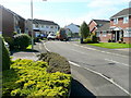
Fosse Close, Abbeymead
Bin day hereabouts is a Tuesday.
Image: © Jonathan Billinger
Taken: 27 Sep 2011
0.20 miles
2
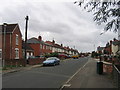
Kingscroft Road, Hucclecote
Looking west along Kingscroft Road.
Image: © David Stowell
Taken: 2 Oct 2005
0.24 miles
3
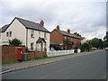
Kingscroft Road, Hucclecote
Some of the older houses on this road. Hucclecote was at one time a village on the road from Gloucester to Cirencester but has now been absorbed as the suburbs of Gloucester.
Image: © David Stowell
Taken: 2 Oct 2005
0.24 miles