IMAGES TAKEN NEAR TO
Winston Road, GLOUCESTER, GL3 2RB
Introduction
This page details the photographs taken nearby to Winston Road, GL3 2RB by members of the Geograph project.
The Geograph project started in 2005 with the aim of publishing, organising and preserving representative images for every square kilometre of Great Britain, Ireland and the Isle of Man.

There are currently over 7.5m images from over14,400 individuals and you can help contribute to the project by visiting https://www.geograph.org.uk
Image Map (Loading...)


Getting Data...Please wait
Leaflet Map data © OpenStreetMap
Images are licensed for reuse under creativecommons.org/licenses/by-sa/2.0
Notes
- Clicking on the map will re-center to the selected point.
- The higher the marker number, the further away the image location is from the centre of the postcode.
Image Listing (9 Images Found)
Images are licensed for reuse under creativecommons.org/licenses/by-sa/2.0
Image
Details
Distance
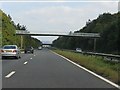
5
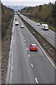
Golden Valley bypass
The A40 Golden Valley bypass provides a direct link between Gloucester and Cheltenham, here it is viewed from the bridge carrying Pirton Lane at Churchdown.
Image: © Philip Halling
Taken: 26 Feb 2011
0.18 miles
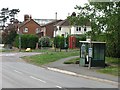
6
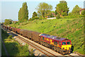
Railway at Churchdown
View from the bridge on Pirton Lane.
Image: © Wayland Smith
Taken: 22 May 2012
0.23 miles
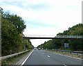
7
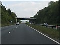
A40 - minor road overbridge at Churchdown
Not surprisingly, this is to the same design as the bridge a short distance to the west. http://www.geograph.org.uk/photo/2087794
Image: © J Whatley
Taken: 22 Sep 2010
0.23 miles

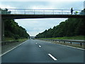
9
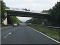
A40 - minor road overbridge at Churchdown
There is another, almost identical example less than a mile further east. http://www.geograph.org.uk/photo/2087797
Image: © J Whatley
Taken: 22 Sep 2010
0.25 miles