IMAGES TAKEN NEAR TO
Brookfield Lane, GLOUCESTER, GL3 2PP
Introduction
This page details the photographs taken nearby to Brookfield Lane, GL3 2PP by members of the Geograph project.
The Geograph project started in 2005 with the aim of publishing, organising and preserving representative images for every square kilometre of Great Britain, Ireland and the Isle of Man.

There are currently over 7.5m images from over14,400 individuals and you can help contribute to the project by visiting https://www.geograph.org.uk
Image Map (Loading...)


Getting Data...Please wait
Leaflet Map data © OpenStreetMap
Images are licensed for reuse under creativecommons.org/licenses/by-sa/2.0
Notes
- Clicking on the map will re-center to the selected point.
- The higher the marker number, the further away the image location is from the centre of the postcode.
Image Listing (7 Images Found)
Images are licensed for reuse under creativecommons.org/licenses/by-sa/2.0
Image
Details
Distance
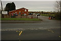
1
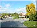
Brookfield Lane
Older housing on the eastern outskirts of Churchdown.
Image: © Jonathan Billinger
Taken: 7 Oct 2011
0.04 miles
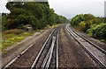
3

Houses at Churchdown
A view from a passing train on the line between Cheltenham and Gloucester, as the reflections indicate. The houses are on Brookfield Road, with a field of rough grazing beside them. In the distance is the Cotswold scarp.
Image: © Derek Harper
Taken: 3 Jan 2013
0.13 miles
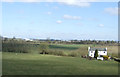
6
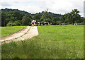
Cows approach riders
Cows from nearby Home Farm check out three riders. Tinkers Hill in the background.
Image: © Pauline E
Taken: 12 Jul 2008
0.19 miles
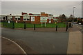
7
Chosen Hill Rugby Club, Churchdown
To give it its full title Chosen Hill Former Pupils Rugby Football Club.
Image: © Philip Halling
Taken: 5 Dec 2009
0.23 miles