IMAGES TAKEN NEAR TO
Brookfield Road, GLOUCESTER, GL3 2PE
Introduction
This page details the photographs taken nearby to Brookfield Road, GL3 2PE by members of the Geograph project.
The Geograph project started in 2005 with the aim of publishing, organising and preserving representative images for every square kilometre of Great Britain, Ireland and the Isle of Man.

There are currently over 7.5m images from over14,400 individuals and you can help contribute to the project by visiting https://www.geograph.org.uk
Image Map
Images are licensed for reuse under creativecommons.org/licenses/by-sa/2.0
Notes
- Clicking on the map will re-center to the selected point.
- The higher the marker number, the further away the image location is from the centre of the postcode.
Image Listing (3 Images Found)
Images are licensed for reuse under creativecommons.org/licenses/by-sa/2.0
Image
Details
Distance
1
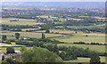
View NE from Churchdown Hill
Also known as Chosen Hill. The view is across the M5, which cuts across the centre of the image, to the town of Cheltenham
Image: © Pauline E
Taken: 3 Jul 2010
0.13 miles
2
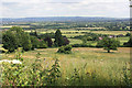
View NE to Cheltenham and the Cotswold Ridge
The M5 passes unseen across the image, between junctions 11 and 11a.
Image: © Pauline E
Taken: 3 Jul 2010
0.14 miles