IMAGES TAKEN NEAR TO
Parton Road, GLOUCESTER, GL3 2JB
Introduction
This page details the photographs taken nearby to Parton Road, GL3 2JB by members of the Geograph project.
The Geograph project started in 2005 with the aim of publishing, organising and preserving representative images for every square kilometre of Great Britain, Ireland and the Isle of Man.

There are currently over 7.5m images from over14,400 individuals and you can help contribute to the project by visiting https://www.geograph.org.uk
Image Map
Images are licensed for reuse under creativecommons.org/licenses/by-sa/2.0
Notes
- Clicking on the map will re-center to the selected point.
- The higher the marker number, the further away the image location is from the centre of the postcode.
Image Listing (9 Images Found)
Images are licensed for reuse under creativecommons.org/licenses/by-sa/2.0
Image
Details
Distance
1
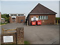
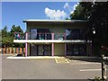
Churchdown Telephone Exchange
Situated in Parton Road, this TE comprises of the redbrick building on the right which dates from the GPO era and the extension on the left which was built more recently. It has the code SSCHN and provides telephone and broadband services to 5,911 residential and 228 non-residential premises in Churchdown plus Badgeworth and Bamfurlong nearby. A white BT warning notice has been fixed to the wall on the left of the photo whilst two red rubbish containers are seen in front of the redbrick building. The numbering range for this TE is (01452) 71xxxx, the (01452) referring to the Gloucester group of sixteen TEs, and its postcode is GL3 2JB.
Image: © David Hillas
Taken: 23 Apr 2019
0.02 miles

3
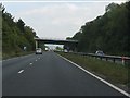
A40 - minor road overbridge at Churchdown
Not surprisingly, this is to the same design as the bridge a short distance to the west. http://www.geograph.org.uk/photo/2087794
Image: © J Whatley
Taken: 22 Sep 2010
0.05 miles
5
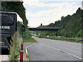
A40 Golden Valley road
The local name for the straight stretch of dual carriageway between Gloucester and Cheltenham, looking east from the Parton Road overbridge.
Image: © Jonathan Billinger
Taken: 14 Jan 2011
0.11 miles
7
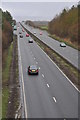
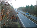
The Golden Valley at Churchdown
The A40 Golden Valley provides a link between Gloucester and Cheltenham.
Image: © Philip Halling
Taken: 26 Feb 2011
0.16 miles
8
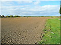
Ploughed field by Buttermilk Lane
The next crop has been sown, apparently, but has not yet emerged.
Image: © Jonathan Billinger
Taken: 7 Oct 2011
0.20 miles
9

Unprotected lay-by on A40 eastbound in Churchdown area
Image: © David Smith
Taken: 15 Aug 2022
0.23 miles