IMAGES TAKEN NEAR TO
Innsworth Lane, GLOUCESTER, GL3 1EY
Introduction
This page details the photographs taken nearby to Innsworth Lane, GL3 1EY by members of the Geograph project.
The Geograph project started in 2005 with the aim of publishing, organising and preserving representative images for every square kilometre of Great Britain, Ireland and the Isle of Man.

There are currently over 7.5m images from over14,400 individuals and you can help contribute to the project by visiting https://www.geograph.org.uk
Image Map (Loading...)


Getting Data...Please wait
Leaflet Map data © OpenStreetMap
Images are licensed for reuse under creativecommons.org/licenses/by-sa/2.0
Notes
- Clicking on the map will re-center to the selected point.
- The higher the marker number, the further away the image location is from the centre of the postcode.
Image Listing (6 Images Found)
Images are licensed for reuse under creativecommons.org/licenses/by-sa/2.0
Image
Details
Distance
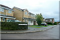
1
Tudor Close, Innsworth
Dormitary suburb of Gloucester adjacent to the RAF Innsworth camp.
Image: © Jonathan Billinger
Taken: 3 Oct 2010
0.15 miles
2
Mary Rose Avenue, Innsworth
Like Image, a suburban road named after a historical event.
Image: © Jonathan Billinger
Taken: 3 Oct 2010
0.19 miles
3
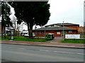
Horizons Youth and Community Centre
This facility is on the north side of the B4063 Cheltenham Road East.
Image: © Jonathan Billinger
Taken: 12 Mar 2009
0.23 miles
4

Churchdown and Innsworth Police Station
On the north side of the B4063 Cheltenham Road East.
Image: © Jonathan Billinger
Taken: 12 Mar 2009
0.23 miles
5
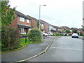
Dolphin Close, Innsworth
Dormitary suburb of Gloucester.
Image: © Jonathan Billinger
Taken: 3 Oct 2010
0.24 miles
6
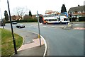
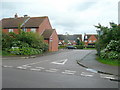
Junction with Innsworth Lane
Junction is with the B4063
Image: © Clint Mann
Taken: 1 Apr 2016
0.25 miles