IMAGES TAKEN NEAR TO
Orchard Park, GLOUCESTER, GL2 9QX
Introduction
This page details the photographs taken nearby to Orchard Park, GL2 9QX by members of the Geograph project.
The Geograph project started in 2005 with the aim of publishing, organising and preserving representative images for every square kilometre of Great Britain, Ireland and the Isle of Man.

There are currently over 7.5m images from over14,400 individuals and you can help contribute to the project by visiting https://www.geograph.org.uk
Image Map
Images are licensed for reuse under creativecommons.org/licenses/by-sa/2.0
Notes
- Clicking on the map will re-center to the selected point.
- The higher the marker number, the further away the image location is from the centre of the postcode.
Image Listing (65 Images Found)
Images are licensed for reuse under creativecommons.org/licenses/by-sa/2.0
Image
Details
Distance
1
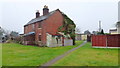
Boarded-up cottages
Adjacent to Orchard Park, Twigworth.
Image: © Jonathan Billinger
Taken: 6 Feb 2012
0.11 miles

3

Orchard Stores
The small shop that serves Orchard Park mobile home park.
Image: © Jonathan Billinger
Taken: 6 Feb 2012
0.12 miles
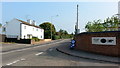
4
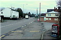
Orchard Caravan Park entrance
The A38 at twigworth, looking north-east towards Tewkesbury.
Image: © Jonathan Billinger
Taken: 27 Jan 2011
0.14 miles
5
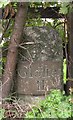
Old Milestone by the A38, Main Street, Twigworth Parish
Metal plate attached to stone post by the A38, in parish of TWIGWORTH (TEWKESBURY District), Main Street; 50m North of Sandhurst turn, in hedge, on West side of road. Gloster incised iron plate, erected by the Cheltenham & Gloucester turnpike trust in the 18th century.
Inscription reads:-
Gloˉſter
II
Grade II Listed. List Entry Number: 1091389
https://historicengland.org.uk/listing/the-list/list-entry/1091389
Milestone Society National ID: GL_GLTW02.
Image: © M Faherty
Taken: 31 Oct 2010
0.14 miles
6
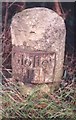
Gloster II
Milestone erected by the Cheltenham & Tewkesbury Turnpike Trust in the 1790's. Happily, the plate has survived.
Image: © John Bayes
Taken: Unknown
0.15 miles
7
Southern boundary of Down Hatherley
The A38 leaves Twigworth and enters Down Hatherley,
a village north of Gloucester, west of Cheltenham and south of Tewkesbury.
Image: © Jaggery
Taken: 2 Apr 2012
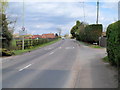
0.16 miles
8
A38 at Twigworth
Looking north from the entrance of the Orchard Mobile Home Park.
Image: © Jonathan Billinger
Taken: 16 Sep 2014
0.16 miles
9

Down Hatherley village sign at Rook Lane Twigworth
Image: © Roy Hughes
Taken: 17 Jul 2021
0.16 miles
10

Entrance to Norton Garden Centre, Down Hatherley
The garden centre http://www.geograph.org.uk/photo/2891863 is on the south side of the A38.
Image: © Jaggery
Taken: 2 Apr 2012
0.16 miles