IMAGES TAKEN NEAR TO
Marlpit Lane, GLOUCESTER, GL2 9LT
Introduction
This page details the photographs taken nearby to Marlpit Lane, GL2 9LT by members of the Geograph project.
The Geograph project started in 2005 with the aim of publishing, organising and preserving representative images for every square kilometre of Great Britain, Ireland and the Isle of Man.

There are currently over 7.5m images from over14,400 individuals and you can help contribute to the project by visiting https://www.geograph.org.uk
Image Map
Images are licensed for reuse under creativecommons.org/licenses/by-sa/2.0
Notes
- Clicking on the map will re-center to the selected point.
- The higher the marker number, the further away the image location is from the centre of the postcode.
Image Listing (37 Images Found)
Images are licensed for reuse under creativecommons.org/licenses/by-sa/2.0
Image
Details
Distance
1
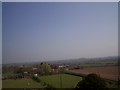
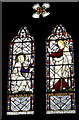
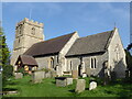
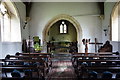
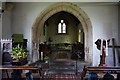
View from tower of St Mary's Church
View from top of St Mary's church at Prior's Norton looking NE compared to altar.
Image: © Malcolm White
Taken: 7 Apr 2007
0.08 miles
2
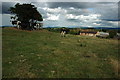
Cows at Norton Court Farm
Friesian milking cows at Norton Court Farm, Prior's Norton.
Image: © Philip Halling
Taken: 7 Aug 2010
0.09 miles
3
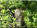
Milestone near Priors Norton
This Grade 2 listed milestone can be found on old maps going back to 1844. It would have originally been marked "Gloucester 4, Tewkesbury 6". It is on a bypassed loop of the main road (now a bridleway) and hidden in the hedge on the north side of the path. The milestone is recorded as GL_GLTW04 on the milestone database. The stone is very worn but a benchmark is just discernible on the top. This benchmark was established during the First primary levelling of England & Wales, and was levelled with a height of 39.7300 feet [12.1097 metres] above mean sea level (Liverpool datum). It was included on the Manchester to Gloucester levelling line. The surveyor's description was "No. 433. Mark on top of the 4th milestone from Gloucester ; 2.78 ft. above centre of road" (Public Abstract p.37).
Image: © Shantavira
Taken: 9 Aug 2014
0.17 miles
4
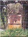
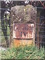
Old Milestone by the former A38, Prior's Norton, Norton Parish
Metal plate attached to stone post by the UC road (was A38), in parish of NORTON (TEWKESBURY District), Prior's Norton, in closed loop of old road, now bridleway, on North side of road. Gloster incised iron plate, erected by the Cheltenham & Gloucester turnpike trust in the 19th century.
Inscription reads:-
Gloˉſter
IV
Grade II listed. List Entry Number: 1303971
https://historicengland.org.uk/listing/the-list/list-entry/1303971
Milestone Society National ID: GL_GLTW04
Image: © John Bayes
Taken: 2 Jun 2005
0.19 miles
5
Gloster IV
Milestone erected by the Cheltenham & Tewkesbury Turnpike Trust in the 1790's. Happily, the plate has survived.
Image: © John Bayes
Taken: Unknown
0.19 miles