IMAGES TAKEN NEAR TO
Longford Lane, GLOUCESTER, GL2 9EU
Introduction
This page details the photographs taken nearby to Longford Lane, GL2 9EU by members of the Geograph project.
The Geograph project started in 2005 with the aim of publishing, organising and preserving representative images for every square kilometre of Great Britain, Ireland and the Isle of Man.

There are currently over 7.5m images from over14,400 individuals and you can help contribute to the project by visiting https://www.geograph.org.uk
Image Map
Images are licensed for reuse under creativecommons.org/licenses/by-sa/2.0
Notes
- Clicking on the map will re-center to the selected point.
- The higher the marker number, the further away the image location is from the centre of the postcode.
Image Listing (4 Images Found)
Images are licensed for reuse under creativecommons.org/licenses/by-sa/2.0
Image
Details
Distance
1
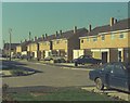
Simon Road
From the driveway of 62 Simon Close.
Little Normans estate.
Image: © Peter Randall-Cook
Taken: Unknown
0.09 miles
2

Simon Road
Simon Road under construction with Rover 75 - Cyclops
Image: © Peter Randall-Cook
Taken: Unknown
0.10 miles
3
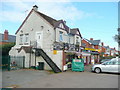
Nick Brown's butcher's shop
No. 1 Innsworth Lane, Longlevens, Gloucester.
Image: © Jonathan Billinger
Taken: 22 Oct 2010
0.17 miles
4

Church Road, Longlevens
Viewed from across the junction with Innsworth Lane, Longford Lane and Oxstalls Lane in the northern suburbs of Gloucester.
Image: © Jonathan Billinger
Taken: 22 Oct 2010
0.21 miles