IMAGES TAKEN NEAR TO
Hartland Hill, GLOUCESTER, GL2 8JY
Introduction
This page details the photographs taken nearby to Hartland Hill, GL2 8JY by members of the Geograph project.
The Geograph project started in 2005 with the aim of publishing, organising and preserving representative images for every square kilometre of Great Britain, Ireland and the Isle of Man.

There are currently over 7.5m images from over14,400 individuals and you can help contribute to the project by visiting https://www.geograph.org.uk
Image Map
Images are licensed for reuse under creativecommons.org/licenses/by-sa/2.0
Notes
- Clicking on the map will re-center to the selected point.
- The higher the marker number, the further away the image location is from the centre of the postcode.
Image Listing (24 Images Found)
Images are licensed for reuse under creativecommons.org/licenses/by-sa/2.0
Image
Details
Distance
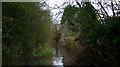
3
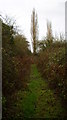
Nice path, nice tree.
In the opposite direction the path was flooded. We had no option but to turn round.
Image: © David Robinson
Taken: 14 Dec 2008
0.10 miles
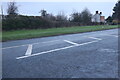
5
Flooded footpath
This won't be the most inviting footpath you ever walk along.
Image: © David Robinson
Taken: 14 Dec 2008
0.14 miles
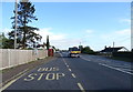
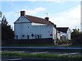
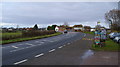
7
The A48 near the Severn Bore public house
Image: © Steve Fareham
Taken: 28 Jan 2009
0.16 miles
8
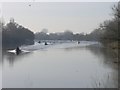
Severn Bore, approaching Severn Bore Inn
8:56am 45 seconds. First sight of the Severn bore as it thunders around the corner, accompanied by numerous surfers, kayakers boats not to mention two helicopters, a light aircraft and a paramotor. The time stamp suggests the bore arrived almost exactly 2 minutes later than that predicted for this location.
Image: © Hywel Williams
Taken: 2 Mar 2010
0.18 miles
9
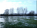
Walmore Common
Wetland area notified as Special Protection Area under EU Birds Directive. Flat low-lying land, difficult to drain to tidal River Severn. Floods in winter and attracts water birds.
Image: © Kevin Gilman
Taken: Unknown
0.18 miles
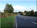
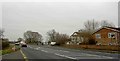
10
The A48 near the Severn Bore Pub
The buildings in the distance are an excellent country butchers.
Image: © David Robinson
Taken: 14 Dec 2008
0.18 miles