IMAGES TAKEN NEAR TO
Maisemore, GLOUCESTER, GL2 8JA
Introduction
This page details the photographs taken nearby to GL2 8JA by members of the Geograph project.
The Geograph project started in 2005 with the aim of publishing, organising and preserving representative images for every square kilometre of Great Britain, Ireland and the Isle of Man.

There are currently over 7.5m images from over14,400 individuals and you can help contribute to the project by visiting https://www.geograph.org.uk
Image Map
Images are licensed for reuse under creativecommons.org/licenses/by-sa/2.0
Notes
- Clicking on the map will re-center to the selected point.
- The higher the marker number, the further away the image location is from the centre of the postcode.
Image Listing (8 Images Found)
Images are licensed for reuse under creativecommons.org/licenses/by-sa/2.0
Image
Details
Distance
1
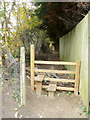
Footpath and stile
Heading north towards the Severn from Walham Lane.
Image: © Jonathan Billinger
Taken: 31 Oct 2010
0.17 miles
2
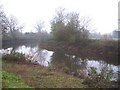
The River Severn at the White Horse. Walham
Looking downstream towards Gloucester, Bristol and the sea from the grounds of the once riverside pub, but now a Chinese restaurant.
Image: © Bob Embleton
Taken: 30 Nov 2005
0.20 miles
3
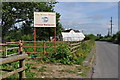
Sign for White Horse Chinese Restaurant
Image: © Nick Mutton 01329 000000
Taken: 24 Jun 2010
0.24 miles
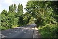
4
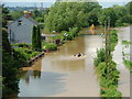
Sandhurst Lane, Walham
Flood waters rising at 3pm.
Image: © Nick Mutton 01329 000000
Taken: 22 Jul 2007
0.24 miles
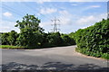
5
Looking along Sandhurst Road
Image: © Nick Mutton 01329 000000
Taken: 24 Jun 2010
0.25 miles
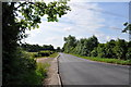
7
Looking along Sandhurst Road
Image: © Nick Mutton 01329 000000
Taken: 24 Jun 2010
0.25 miles
8
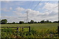
Pylon and high voltage cables
Image: © Nick Mutton 01329 000000
Taken: 24 Jun 2010
0.25 miles