IMAGES TAKEN NEAR TO
Maisemore, GLOUCESTER, GL2 8HE
Introduction
This page details the photographs taken nearby to GL2 8HE by members of the Geograph project.
The Geograph project started in 2005 with the aim of publishing, organising and preserving representative images for every square kilometre of Great Britain, Ireland and the Isle of Man.

There are currently over 7.5m images from over14,400 individuals and you can help contribute to the project by visiting https://www.geograph.org.uk
Image Map
Images are licensed for reuse under creativecommons.org/licenses/by-sa/2.0
Notes
- Clicking on the map will re-center to the selected point.
- The higher the marker number, the further away the image location is from the centre of the postcode.
Image Listing (47 Images Found)
Images are licensed for reuse under creativecommons.org/licenses/by-sa/2.0
Image
Details
Distance
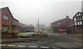
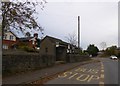
2
Phone box and bus shelter, Maisemore
On the A417, looking towards Ledbury.
Image: © Pauline E
Taken: 14 Mar 2008
0.04 miles
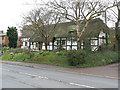
3
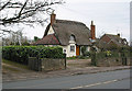
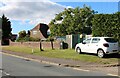
Thatched cottage, Maisemore
This must have known much quieter times. It now sits on the busy A417 to Ledbury.
Image: © Pauline E
Taken: 14 Mar 2008
0.05 miles
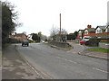
4
Orchard Way, Maisemore, Glos
Beside the busy main road.
Image: © Jeremy Bolwell
Taken: 9 Oct 2019
0.05 miles
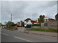
5
Stanleigh Terrace, Maisemore
Not yet on my map.
Image: © Pauline E
Taken: 14 Mar 2008
0.05 miles
6
Timbered cottage, Maisemore
On the busy A417.
Image: © Pauline E
Taken: 14 Mar 2008
0.06 miles
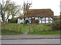
8
Semi-detached thatched, Maisemore
The larger cottage is thatched, the smaller one has a slate roof.
Image: © Pauline E
Taken: 14 Mar 2008
0.07 miles
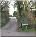
10

Persh Lane, Maisemore
A no through road leading to Persh Farm.
Image: © Pauline E
Taken: 14 Mar 2008
0.09 miles