IMAGES TAKEN NEAR TO
Elver Close, GLOUCESTER, GL2 8FP
Introduction
This page details the photographs taken nearby to Elver Close, GL2 8FP by members of the Geograph project.
The Geograph project started in 2005 with the aim of publishing, organising and preserving representative images for every square kilometre of Great Britain, Ireland and the Isle of Man.

There are currently over 7.5m images from over14,400 individuals and you can help contribute to the project by visiting https://www.geograph.org.uk
Image Map
Images are licensed for reuse under creativecommons.org/licenses/by-sa/2.0
Notes
- Clicking on the map will re-center to the selected point.
- The higher the marker number, the further away the image location is from the centre of the postcode.
Image Listing (9 Images Found)
Images are licensed for reuse under creativecommons.org/licenses/by-sa/2.0
Image
Details
Distance
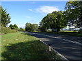
5
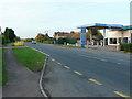
A48 at Minsterworth
Looking south early on a Saturday morning.
Image: © Jonathan Billinger
Taken: 30 Oct 2010
0.18 miles
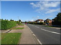
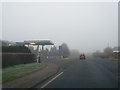
7
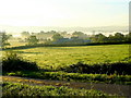
The Vale of Gloucester 3
The early morning autumnal mist hangs over the River Severn, with the Cotswold scarp in the distance..
Image: © Jonathan Billinger
Taken: 16 Oct 2010
0.20 miles
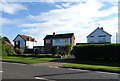
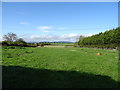
9
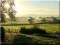
The Vale of Gloucester 2
Looking east from the A48 near Minsterworth with Robin's Wood Hill in the centre distance.
Image: © Jonathan Billinger
Taken: 16 Oct 2010
0.22 miles