IMAGES TAKEN NEAR TO
Wood Mews, GLOUCESTER, GL2 8BX
Introduction
This page details the photographs taken nearby to Wood Mews, GL2 8BX by members of the Geograph project.
The Geograph project started in 2005 with the aim of publishing, organising and preserving representative images for every square kilometre of Great Britain, Ireland and the Isle of Man.

There are currently over 7.5m images from over14,400 individuals and you can help contribute to the project by visiting https://www.geograph.org.uk
Image Map
Images are licensed for reuse under creativecommons.org/licenses/by-sa/2.0
Notes
- Clicking on the map will re-center to the selected point.
- The higher the marker number, the further away the image location is from the centre of the postcode.
Image Listing (84 Images Found)
Images are licensed for reuse under creativecommons.org/licenses/by-sa/2.0
Image
Details
Distance
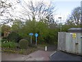
1
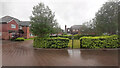
Horseshoe Drive, Over
A fairly exclusive cul-de-sac off the Over bypass.
Image: © Jonathan Billinger
Taken: 30 Jul 2021
0.05 miles
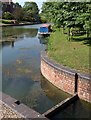
3
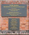
Plaque at Over Basin
The plaques commemorating the restoration of the canal basin. For more details see http://www.h-g-canal.org.uk
Image: © David Stowell
Taken: 2 Oct 2005
0.08 miles
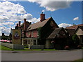
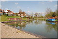
4
Over Basin
The restored basin of the Hereford and Gloucester Canal. http://www.h-g-canal.org.uk/ The temporary bridge in the corner is the location of the yet to be restored lock into the River Severn. The newly built Wharf House in the centre of the picture was constructed by the canal restoration society and now houses a shop and a very smart restaurant. http://www.thewharfhouse.co.uk/ Soon it will also provide accommodation.
Image: © David Stowell
Taken: 2 Oct 2005
0.08 miles
5
Sneaky stuff - Over
The convoluted way in which the National Cycle Network avoids the A40. Here a narrow path, floods willing, drops away to cross the A40 by going under the new bridge over the Severn. This allows access to Telford's bridge now closed to motorised traffic. Cunning and it works.
Image: © Richard Webb
Taken: 16 Apr 2016
0.09 miles
6
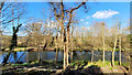
Old canal basin
Viewed from one of the houses on the Horseshoe Drive estate, looking out over the Leadon floodplain.
Image: © Jonathan Billinger
Taken: 7 Mar 2022
0.09 miles
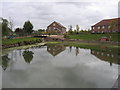
7
Canal basin, Over
See also http://www.geograph.org.uk/gridref/SO8119?class=Canal+basin . In the foreground is the northwest entrance to the lock that joined the canal to the River Severn. From the air, the basin forms the shape of a question mark, with the lock (still containing water) as the dot beneath.
Image: © Derek Harper
Taken: 22 Jun 2010
0.09 miles
9
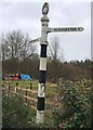
Direction Sign ? Signpost
Relocated to Wharf House redevelopment in Over, to the east of Horseshore Drive, in Highnam parish. 2 arms and annulus finial.
Milestone Society National ID: GL_SO8119
Image: © S Kosciow
Taken: 13 Jan 2020
0.09 miles
10
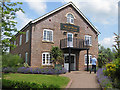
The Wharf House, Over Basin
The restaurant stands on the site of the original lock keeper's cottage, built in 1831 when the cellar was used to stable the mules which pulled the boats along the Herefordshire and Gloucestershire canal. The brick arches in the restaurant have been recycled from the cottage.
Image: © Pauline E
Taken: 27 Jun 2009
0.09 miles