IMAGES TAKEN NEAR TO
Fromebridge, GLOUCESTER, GL2 7NJ
Introduction
This page details the photographs taken nearby to Fromebridge, GL2 7NJ by members of the Geograph project.
The Geograph project started in 2005 with the aim of publishing, organising and preserving representative images for every square kilometre of Great Britain, Ireland and the Isle of Man.

There are currently over 7.5m images from over14,400 individuals and you can help contribute to the project by visiting https://www.geograph.org.uk
Image Map
Images are licensed for reuse under creativecommons.org/licenses/by-sa/2.0
Notes
- Clicking on the map will re-center to the selected point.
- The higher the marker number, the further away the image location is from the centre of the postcode.
Image Listing (29 Images Found)
Images are licensed for reuse under creativecommons.org/licenses/by-sa/2.0
Image
Details
Distance
1
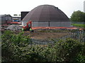
Highway Agency depot
A new structure being built at the motorway maintenance compound close to Eastington next to the M5 Jct13.
Image: © Vincent Jones
Taken: 10 May 2006
0.05 miles
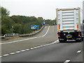
4
M5 approaching junction 13, northbound
A lot of infrastructure in view. Once under the power lines, the motorway bridges the River Frome before reaching the A419 junction, the bridges of which are visible in the distance.
Image: © J Whatley
Taken: 31 Aug 2010
0.09 miles
5
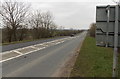
A419 between the M5 and the A38
Looking NW along the A419 from the edge of M5 motorway junction 13.
Image: © Jaggery
Taken: 24 Mar 2013
0.09 miles
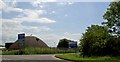
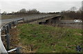
6
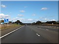
Junction 13 of M5
The A419 crosses the M5 in the valley of the River Frome
Image: © David Smith
Taken: 16 Oct 2012
0.09 miles
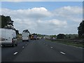
7
M5 Motorway, A419 Flyover at Junction 13
Image: © David Dixon
Taken: 13 Dec 2013
0.10 miles
8
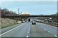
From overbridge to overbridge at M5 junction 13
Looking SW across the M5 from one carriageway of the A419 towards
the opposite carriageway of the A419. The bridge edges are 85 metres apart.
Image: © Jaggery
Taken: 24 Mar 2013
0.11 miles
9
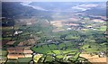
M5 Junction 13
Several major route ways travelling in the south-west to north-east direction (Bristol to Birmingham) appear here.
The meandering river Severn was superseded by the Gloucester to Sharpness canal and the traffic on the A38 now takes the M5.
The photo was taken from above the Bristol to Birmingham railway line from an aeroplane travelling to Gloucester Airport.
The A38 runs parallel to the M5 about 1 km away.
Image: © Bob Embleton
Taken: 22 Aug 2009
0.12 miles
10
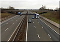
A419 bridge over the M5 motorway
Part of M5 motorway junction 13. This bridge carries SE bound traffic.
A similar bridge for NW bound A419 traffic is 90 metres away.
Image: © Jaggery
Taken: 24 Mar 2013
0.13 miles