IMAGES TAKEN NEAR TO
Moreton Valence, GLOUCESTER, GL2 7NH
Introduction
This page details the photographs taken nearby to GL2 7NH by members of the Geograph project.
The Geograph project started in 2005 with the aim of publishing, organising and preserving representative images for every square kilometre of Great Britain, Ireland and the Isle of Man.

There are currently over 7.5m images from over14,400 individuals and you can help contribute to the project by visiting https://www.geograph.org.uk
Image Map
Images are licensed for reuse under creativecommons.org/licenses/by-sa/2.0
Notes
- Clicking on the map will re-center to the selected point.
- The higher the marker number, the further away the image location is from the centre of the postcode.
Image Listing (10 Images Found)
Images are licensed for reuse under creativecommons.org/licenses/by-sa/2.0
Image
Details
Distance

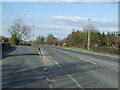
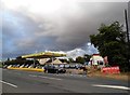
3

Lay-by at Parkend
Lay-by at Parkend off the A38, formerly this lay-by was the route of the road.
Image: © Philip Halling
Taken: 16 Feb 2013
0.03 miles

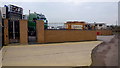
6

Grand entrance?
The start of a property project to the north Hiltmead Lane.
Image: © Jonathan Billinger
Taken: 27 Jan 2017
0.11 miles
7
Fairground storage
Behind these gates and walls is standing area for fairground equipment, transport and accommodation.
Image: © Jonathan Billinger
Taken: 27 Jan 2017
0.11 miles
8
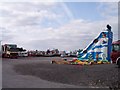
Fairground Winter Home, Parkend
Where fairground rides migrate to over the winter months.
Image: © Bob Embleton
Taken: 22 Mar 2006
0.17 miles
10

Lots of Mistletoe next to the A38, heading south
Image: © Rob Purvis
Taken: 4 Feb 2024
0.24 miles