IMAGES TAKEN NEAR TO
Church Lane, GLOUCESTER, GL2 7NB
Introduction
This page details the photographs taken nearby to Church Lane, GL2 7NB by members of the Geograph project.
The Geograph project started in 2005 with the aim of publishing, organising and preserving representative images for every square kilometre of Great Britain, Ireland and the Isle of Man.

There are currently over 7.5m images from over14,400 individuals and you can help contribute to the project by visiting https://www.geograph.org.uk
Image Map
Images are licensed for reuse under creativecommons.org/licenses/by-sa/2.0
Notes
- Clicking on the map will re-center to the selected point.
- The higher the marker number, the further away the image location is from the centre of the postcode.
Image Listing (9 Images Found)
Images are licensed for reuse under creativecommons.org/licenses/by-sa/2.0
Image
Details
Distance
1
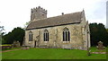
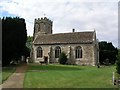
St. Stephen's church, Moreton Valence
Owes its location to the slightly raised platform of ground on the edge of the Severn flood plain.
Image: © Jonathan Billinger
Taken: 13 Jul 2017
0.03 miles
2
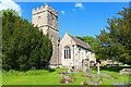
St Stephen's
Church at Moreton Valence.
Image: © Wayland Smith
Taken: 31 May 2021
0.03 miles
3
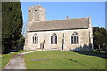
Moreton Valence church
Moreton Valence church is dedicated to St Stephen. Pevsner informs the church was given to the Bishop of Hereford Cathedral around 1150 by Roger Little, Earl of Hereford. I presume the church is now in the Diocese of Gloucester. The nave and chancel date from the 12th century and the tower from the 15th century.
Image: © Philip Halling
Taken: 11 Feb 2012
0.04 miles
4
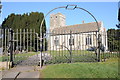
Moreton Valence church
Moreton Valence church framed by the arch above the entrance gate. The church is dedicated to St Stephen. Pevsner informs that the church was given to the Bishop of Hereford Cathedral around 1150 by Roger Little, Earl of Hereford. I assume the church is now in the Diocese of Gloucester. The nave and chancel date from the 12th century and the tower from the 15th century.
Image: © Philip Halling
Taken: 11 Feb 2012
0.04 miles
5
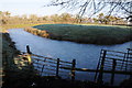
Moat at Moreton Valence
This frozen moat at Moreton Valence is immediately to the north of the parish church.
Image: © Philip Halling
Taken: 11 Feb 2012
0.05 miles
7
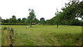
Sheep in an old orchard
On the opposite side of the lane from the church.
A path heads south across the flood plain to Whitminster from here.
Image: © Jonathan Billinger
Taken: 13 Jul 2017
0.07 miles
8
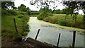
Moreton Valence Rhyne
This watercourse meanders gently to the River Severn at Epney.
Image: © Jonathan Billinger
Taken: 13 Jul 2017
0.09 miles
9
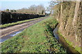
No through road, Moreton Valence
This no through road at Moreton Valence passes the church and provides access to Moor Farm which is set back down an avenue. The water course on the right is named on the OS map as Moreton Valence Rhyne.
Image: © Philip Halling
Taken: 11 Feb 2012
0.19 miles