IMAGES TAKEN NEAR TO
Fretherne, GLOUCESTER, GL2 7JQ
Introduction
This page details the photographs taken nearby to Fretherne, GL2 7JQ by members of the Geograph project.
The Geograph project started in 2005 with the aim of publishing, organising and preserving representative images for every square kilometre of Great Britain, Ireland and the Isle of Man.

There are currently over 7.5m images from over14,400 individuals and you can help contribute to the project by visiting https://www.geograph.org.uk
Image Map
Images are licensed for reuse under creativecommons.org/licenses/by-sa/2.0
Notes
- Clicking on the map will re-center to the selected point.
- The higher the marker number, the further away the image location is from the centre of the postcode.
Image Listing (51 Images Found)
Images are licensed for reuse under creativecommons.org/licenses/by-sa/2.0
Image
Details
Distance
1
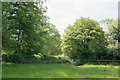
Path on the Skylark Walk
The community at Arlingham have set up a number of walks around the village and beside the Severn. This section is part of the "Skylark Walk" and goes on to the Long Wood ( see Image ), alongside the Severn and then back to Arlingham.
Image: © Doug Lee
Taken: 4 May 2014
0.05 miles
2
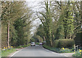
Road through Fretherne Wood
A small patch of woodland, west of Fretherne.
Image: © Pauline E
Taken: 10 Apr 2010
0.06 miles
3
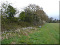
Meadow's edge in spring
Spring blossom appearing and the hedgerow leafing up. View north-east towards Fretherne.
Image: © Jonathan Billinger
Taken: 11 Apr 2008
0.07 miles
4
Footpath and stile
Access from Fretherne to the Severn Way.
Image: © Dr Duncan Pepper
Taken: 21 Jul 2016
0.08 miles
5
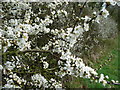
Sloe blossom
White hedgerows in early April in southern Britain generally means sloe, or blackthorn; Prunus spinosa.
Detail from the hedge in Image
Image: © Jonathan Billinger
Taken: 11 Apr 2008
0.09 miles
6
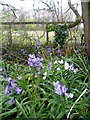
Bluebells and cuckooflower
In the base of a hedge near Image
Image: © Jonathan Billinger
Taken: 11 Apr 2008
0.11 miles
7
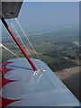
Over Hock Cliff
Image can be seen behind the wing; the house is "The Reddings". Beyond is the scattered settlement of Fretherne. The lane lies within the Arlingham bend; the Severn upstream can be seen in the background. Seen from a Stampe SV4C on a flight from Gloucestershire Airport.
Image: © Derek Harper
Taken: 21 Mar 2009
0.14 miles
8
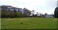
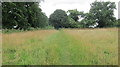
Long Wood and The Reddings
View north-west from the Severn Way footpath near Fretherne.
Image: © Jonathan Billinger
Taken: 11 Apr 2008
0.15 miles
9
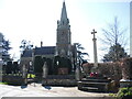
Fretherne's tributes
The church of St Mary the Virgin and the war memorial are close at heart as well as at hand.
Image: © Neil Owen
Taken: 4 Apr 2023
0.15 miles
10
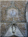
Clock above the north porch
The entrance is at the base of the tower and a clock is set into the second stage.
Image: © Neil Owen
Taken: 4 Apr 2023
0.16 miles