IMAGES TAKEN NEAR TO
Water Lane, GLOUCESTER, GL2 7DZ
Introduction
This page details the photographs taken nearby to Water Lane, GL2 7DZ by members of the Geograph project.
The Geograph project started in 2005 with the aim of publishing, organising and preserving representative images for every square kilometre of Great Britain, Ireland and the Isle of Man.

There are currently over 7.5m images from over14,400 individuals and you can help contribute to the project by visiting https://www.geograph.org.uk
Image Map
Images are licensed for reuse under creativecommons.org/licenses/by-sa/2.0
Notes
- Clicking on the map will re-center to the selected point.
- The higher the marker number, the further away the image location is from the centre of the postcode.
Image Listing (5 Images Found)
Images are licensed for reuse under creativecommons.org/licenses/by-sa/2.0
Image
Details
Distance
2
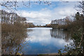
Frampton on Severn sailing lake
The lake is an old gravel pit covering 40 acres and is used by Frampton on Severn sailing club. It is one of two large lakes by the village of Frampton on Severn.
Image: © Vincent Jones
Taken: 3 Apr 2006
0.14 miles
3
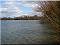
Trees and grassland on the eastern edge of the lake
Image: © Doug Lee
Taken: 6 Mar 2016
0.14 miles

5
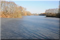
Frozen lake at Frampton Court
Lake in the parkland of Frampton Court, photographed here on a cold frosty morning with a layer of ice on its surface after a number of frosty days.
Image: © Philip Halling
Taken: 11 Feb 2012
0.19 miles