
IMAGES TAKEN NEAR TO
Berkeley Court, GLOUCESTER, GL2 7DT
Introduction
This page details the photographs taken nearby to Berkeley Court, GL2 7DT by members of the Geograph project.
The Geograph project started in 2005 with the aim of publishing, organising and preserving representative images for every square kilometre of Great Britain, Ireland and the Isle of Man.

There are currently over 7.5m images from over14,400 individuals and you can help contribute to the project by visiting https://www.geograph.org.uk
Image Map
Images are licensed for reuse under creativecommons.org/licenses/by-sa/2.0
Notes
- Clicking on the map will re-center to the selected point.
- The higher the marker number, the further away the image location is from the centre of the postcode.
Image Listing (61 Images Found)
Images are licensed for reuse under creativecommons.org/licenses/by-sa/2.0
Image
Details
Distance
1

Slimbridge : Moorend Lane
A lane heading into the village of Slimbridge.
Image: © Lewis Clarke
Taken: 25 Feb 2017
0.02 miles
2

Slimbridge : Footpath
A path from Moorend Lane to Tyning Crescent.
Image: © Lewis Clarke
Taken: 25 Feb 2017
0.06 miles
3

Old-style traffic sign, Slimbridge
Below a modern triangular sign is an old-style sign showing bends for 1 mile. There are glass beads (cat's eyes) in the Z part of the sign. Located on St John's Road at the edge of Allen & Elliott's garage. http://www.geograph.org.uk/photo/2735889
The garage has 3 old-style pumps.http://www.geograph.org.uk/photo/2735891
Image: © Jaggery
Taken: 18 Dec 2011
0.08 miles
4
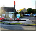
Three old-style Butler fuel pumps, Slimbridge
The pumps are in the forecourt of the Allen & Elliot garage.http://www.geograph.org.uk/photo/2735889
The one on the left is for diesel. The one on the right is for unleaded petrol.
Image: © Jaggery
Taken: 18 Dec 2011
0.08 miles
5

Slimbridge garage
St John's Road premises of Allen & Elliott.
Image: © Jaggery
Taken: 18 Dec 2011
0.08 miles
6

Grade II listed Churchend Farmhouse, Slimbridge
Located on St John's Road near the Moorend Lane junction. Built in the mid 18th century, the farmhouse was Grade II listed in April 1984.
Image: © Jaggery
Taken: 18 Dec 2011
0.11 miles
7

Moorend Lane, Slimbridge
The eastern end of the lane, viewed from St John's Road.
Image: © Jaggery
Taken: 18 Dec 2011
0.11 miles
8

Field viewed from a stile near Slimbridge pavilion
Image: © Jaggery
Taken: 18 Dec 2011
0.11 miles
9

Abandoned petrol pumps in Slimbridge
The garage is still in business
Image: © David Howard
Taken: 28 Jul 2018
0.13 miles
10

Abandoned petrol pumps in Slimbridge
The garage is still active but these have not been used for a long time.
Image: © David Howard
Taken: 28 Jul 2018
0.13 miles