IMAGES TAKEN NEAR TO
Ryalls Lane, GLOUCESTER, GL2 7AT
Introduction
This page details the photographs taken nearby to Ryalls Lane, GL2 7AT by members of the Geograph project.
The Geograph project started in 2005 with the aim of publishing, organising and preserving representative images for every square kilometre of Great Britain, Ireland and the Isle of Man.

There are currently over 7.5m images from over14,400 individuals and you can help contribute to the project by visiting https://www.geograph.org.uk
Image Map
Images are licensed for reuse under creativecommons.org/licenses/by-sa/2.0
Notes
- Clicking on the map will re-center to the selected point.
- The higher the marker number, the further away the image location is from the centre of the postcode.
Image Listing (24 Images Found)
Images are licensed for reuse under creativecommons.org/licenses/by-sa/2.0
Image
Details
Distance
1
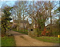
Entrance to Rolls Court, Cambridge
The entrance is at a 90-degree bend in the course of Ryalls Lane in the Gloucestershire village of Cambridge.
Image: © Jaggery
Taken: 18 Dec 2011
0.15 miles
2

Farmhouse, Wharf Farm, Cambridge
The farmhouse is adjacent to Bristol Road (A38) in the Gloucestershire village of Cambridge.
Since about 1980, Wharf Farm has had a herd of milking goats. Most of the goats' milk is made into cheese; some is sold for drinking.
Image: © Jaggery
Taken: 18 Dec 2011
0.16 miles
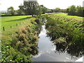
5
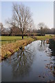
Tree reflected in the River Cam
Tree reflected in the River Cam on the section of river between the village of Cambridge and the Gloucester and Sharpness Canal.
Image: © Philip Halling
Taken: 11 Feb 2012
0.18 miles
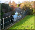
6
The River Cam looking upstream above the flood control gate
Image: © Dr Duncan Pepper
Taken: 23 Sep 2011
0.18 miles
7
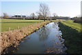
River Cam
The OS map names this as the Cambridge Arm of the River Cam, pictured here from a bridge near a pumping station between the village of Cambridge and the Gloucester and Sharpness Canal.
Image: © Philip Halling
Taken: 11 Feb 2012
0.19 miles
8
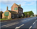
The George Inn, Cambridge
Located between Bristol Road (the A38) and the River Cam in the Gloucestershire village of Cambridge.
Image: © Jaggery
Taken: 18 Dec 2011
0.20 miles
9
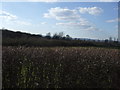
River Cam flows away from Bristol Road, Cambridge
Viewed from the edge of The George Inn. http://www.geograph.org.uk/photo/2735287
The Cam is a small river in Gloucestershire. It flows into the Gloucester and Sharpness Canal about a mile ahead. Before the canal was opened in 1827, the Cam flowed into the River Severn at Frampton Pill.
Image: © Jaggery
Taken: 18 Dec 2011
0.20 miles
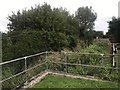
10

Ellis Transport yard, Cambridge
Viewed across Bristol Road (A38). The yard is part of Ellis Transport's premises, The Motor Garage, in the Gloucestershire village of Cambridge.
Image: © Jaggery
Taken: 18 Dec 2011
0.20 miles