IMAGES TAKEN NEAR TO
Sudmeadow Road, GLOUCESTER, GL2 5HD
Introduction
This page details the photographs taken nearby to Sudmeadow Road, GL2 5HD by members of the Geograph project.
The Geograph project started in 2005 with the aim of publishing, organising and preserving representative images for every square kilometre of Great Britain, Ireland and the Isle of Man.

There are currently over 7.5m images from over14,400 individuals and you can help contribute to the project by visiting https://www.geograph.org.uk
Image Map
Images are licensed for reuse under creativecommons.org/licenses/by-sa/2.0
Notes
- Clicking on the map will re-center to the selected point.
- The higher the marker number, the further away the image location is from the centre of the postcode.
Image Listing (173 Images Found)
Images are licensed for reuse under creativecommons.org/licenses/by-sa/2.0
Image
Details
Distance
1
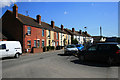
Houses on Sudmeadow Road
This terrace occupies the south eastern end of the road, the rest is all industrial units.
Image: © David Lally
Taken: 8 Apr 2010
0.01 miles
3
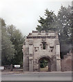
Llanthony Priory gatehouse
Erected by Prior Henry Deane in the late 15th century. http://www.livinggloucester.co.uk/histories/monasteries/llanthony_priory/
Image: © Keith Edkins
Taken: 28 Jul 1996
0.07 miles
4

Remains of the gatehouse, Llanthony Secunda
Founded in 1136 by Miles of Gloucester for Augustinian canons fleeing from Llanthony Priory in the Black Mountains, which had been overrun by the Welsh. 'A splendid green oasis amidst seedy industrial development' says Pevsner, although in 2014 the green oasis is an unofficial playing field for neighbouring Gloucestershire College. A few scanty remains include this portion of the central range between the inner and outer courts. There is no sign of the magnificent abbey church, but part of the gatehouse on Llanthony Road survives.
Image: © Philip Pankhurst
Taken: 19 Jun 2014
0.07 miles
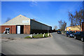
5
Buildings at Spinnaker Junction
Spinnaker House, the hexagonal office building on the left, can be seen in Image Closer at hand are the commercial premises of two building firms and a motor workshop.
Image: © Derek Harper
Taken: 23 Jun 2010
0.09 miles
6
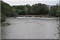
Weir on the East Channel
This weir on the River Severn's on the East Channel at Gloucester is holding back a considerable amount of debris.
Image: © Philip Halling
Taken: 7 May 2011
0.09 miles
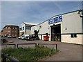
7

C P Glass
In one of the units on Sudmeadow Road.
Image: © David Lally
Taken: 8 Apr 2010
0.10 miles
8
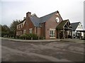
The High Orchard
Instant traditional pub.
Image: © Jonathan Thacker
Taken: 28 Jun 2014
0.10 miles
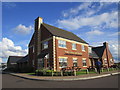
9
Gloucester, High Orchard
Roadhouse type public house on Hempsted Lane. Central counter, with drinking and eating areas on three sides. Cask ales on offer at my visit: Marston's Pedigree, Wychwood Hobgoblin.
Image: © Mike Faherty
Taken: 14 Oct 2018
0.10 miles
10
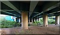
Beneath Llanthony Bridge
The new bridge carrying the A430 across the eastern arm of the Severn from Castle Meads on Alney Island.
Image: © Derek Harper
Taken: 22 Jun 2010
0.11 miles