IMAGES TAKEN NEAR TO
Byron Avenue, GLOUCESTER, GL2 5AG
Introduction
This page details the photographs taken nearby to Byron Avenue, GL2 5AG by members of the Geograph project.
The Geograph project started in 2005 with the aim of publishing, organising and preserving representative images for every square kilometre of Great Britain, Ireland and the Isle of Man.

There are currently over 7.5m images from over14,400 individuals and you can help contribute to the project by visiting https://www.geograph.org.uk
Image Map
Images are licensed for reuse under creativecommons.org/licenses/by-sa/2.0
Notes
- Clicking on the map will re-center to the selected point.
- The higher the marker number, the further away the image location is from the centre of the postcode.
Image Listing (6 Images Found)
Images are licensed for reuse under creativecommons.org/licenses/by-sa/2.0
Image
Details
Distance
1
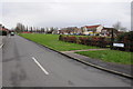
Masefield Avenue, Podsmead
Masefield Avenue bounds the one side of this open, urban, green area in Podsmead in the southern suburbs of Gloucester, with Scott Avenue bounding the other side.
Image: © Philip Halling
Taken: 26 Jan 2013
0.17 miles
2
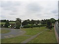
Crypt School, Podsmead, Gloucester
The playing fields and entrance to school drive with the school in amongst the trees.
Image: © David Stowell
Taken: 18 Sep 2005
0.17 miles
3
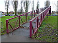
Purple footbridge over the A38
A shallow-enough grade for prams and pushchairs, presumably.
Image: © Jonathan Billinger
Taken: 27 Dec 2012
0.20 miles
4
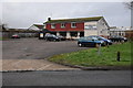
The Gladiator
The Gladiator public house on Tuffley Lane in Lower Tuffley area in Gloucester.
Image: © Philip Halling
Taken: 26 Jan 2013
0.24 miles
6
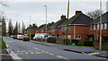
Podsmead Road
Suburban link road between Linden and Lower Tuffley, Gloucester.
Image: © Jonathan Billinger
Taken: 27 Dec 2012
0.25 miles