IMAGES TAKEN NEAR TO
Weavers Road, GLOUCESTER, GL2 4WX
Introduction
This page details the photographs taken nearby to Weavers Road, GL2 4WX by members of the Geograph project.
The Geograph project started in 2005 with the aim of publishing, organising and preserving representative images for every square kilometre of Great Britain, Ireland and the Isle of Man.

There are currently over 7.5m images from over14,400 individuals and you can help contribute to the project by visiting https://www.geograph.org.uk
Image Map
Images are licensed for reuse under creativecommons.org/licenses/by-sa/2.0
Notes
- Clicking on the map will re-center to the selected point.
- The higher the marker number, the further away the image location is from the centre of the postcode.
Image Listing (8 Images Found)
Images are licensed for reuse under creativecommons.org/licenses/by-sa/2.0
Image
Details
Distance
1
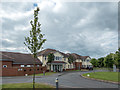
Chestnut Court, Quedgeley, Gloucestershire
Chestnut Court is a Care Home close to Tesco's.
Image: © Christine Matthews
Taken: 18 Jun 2016
0.13 miles
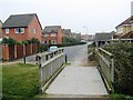
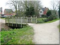
3
Carter's Orchard, Quedgeley
Quedgeley is a sprawling southern suburb of Gloucester.
Image: © Jonathan Billinger
Taken: 27 Dec 2012
0.17 miles
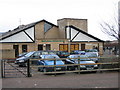
6
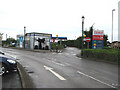
Car wash, Tesco, Quedgeley
The roundabout nearby is actually signed 'Tesco Roundabout'.
Unleaded at 110.9 a litre today.
Image: © Pauline E
Taken: 4 May 2008
0.21 miles
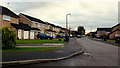
7

Cooper's Elm, Quedgeley
Quedgeley is a sprawling southern suburb of Gloucester.
Image: © Jonathan Billinger
Taken: 27 Dec 2012
0.22 miles
8
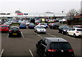
Tesco Extra, Quedgeley
Superstore viewed from the west side of Bristol Road.
Image: © Jaggery
Taken: 22 Jan 2017
0.24 miles