IMAGES TAKEN NEAR TO
Bristol Road, GLOUCESTER, GL2 4NB
Introduction
This page details the photographs taken nearby to Bristol Road, GL2 4NB by members of the Geograph project.
The Geograph project started in 2005 with the aim of publishing, organising and preserving representative images for every square kilometre of Great Britain, Ireland and the Isle of Man.

There are currently over 7.5m images from over14,400 individuals and you can help contribute to the project by visiting https://www.geograph.org.uk
Image Map
Images are licensed for reuse under creativecommons.org/licenses/by-sa/2.0
Notes
- Clicking on the map will re-center to the selected point.
- The higher the marker number, the further away the image location is from the centre of the postcode.
Image Listing (19 Images Found)
Images are licensed for reuse under creativecommons.org/licenses/by-sa/2.0
Image
Details
Distance
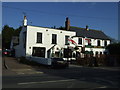
4
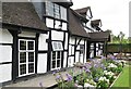
Quedgeley - The Thatch Inn
Bristol Road in the Gloucester suburb of Quedgeley - a hotel, bar & restaurant that dates back to the 14th century.
www.thethatchinn.co.uk
Image: © Colin Smith
Taken: 1 Aug 2019
0.11 miles
5
Quedgeley - The Thatch Inn
Bristol Road in the Gloucester suburb of Quedgeley - a hotel, bar & restaurant that dates back to the 14th century.
www.thethatchinn.co.uk
Image: © Colin Smith
Taken: 1 Aug 2019
0.11 miles
6

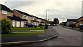
Cooper's Elm, Quedgeley
Quedgeley is a sprawling southern suburb of Gloucester.
Image: © Jonathan Billinger
Taken: 27 Dec 2012
0.13 miles
7
Carter's Orchard, Quedgeley
Quedgeley is a sprawling southern suburb of Gloucester.
Image: © Jonathan Billinger
Taken: 27 Dec 2012
0.16 miles
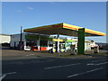
8
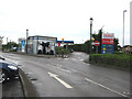
Car wash, Tesco, Quedgeley
The roundabout nearby is actually signed 'Tesco Roundabout'.
Unleaded at 110.9 a litre today.
Image: © Pauline E
Taken: 4 May 2008
0.17 miles

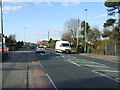
10
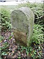
Old Milestone by the B4008, Bristol Road, Quedgeley
Metal plate attached to stone post by the B4008 (was A38), in parish of Quedgeley (Gloucester District), Bristol Road, just South of entrance to retail park partially hidden in shrubbery, on East side of road; relocated because of development from the opposite side of road, and wrongly re-erected back to front. Gloucester Cross iron plate, erected by the Southgate Turnpike Trust in the 19th century.
Inscription reads:-
TO
GLOUCESTER
CROSS
3
TO
BRISTOL
31
Carved benchmark and rivet on top.
Grade II listed. List Entry Number:1340606
https://historicengland.org.uk/listing/the-list/list-entry/1340606
Milestone Society National ID: GL_GLBR03.
Image: © Milestone Society
Taken: 12 Oct 2018
0.21 miles