IMAGES TAKEN NEAR TO
Redshank Way, GLOUCESTER, GL2 4DZ
Introduction
This page details the photographs taken nearby to Redshank Way, GL2 4DZ by members of the Geograph project.
The Geograph project started in 2005 with the aim of publishing, organising and preserving representative images for every square kilometre of Great Britain, Ireland and the Isle of Man.

There are currently over 7.5m images from over14,400 individuals and you can help contribute to the project by visiting https://www.geograph.org.uk
Image Map
Images are licensed for reuse under creativecommons.org/licenses/by-sa/2.0
Notes
- Clicking on the map will re-center to the selected point.
- The higher the marker number, the further away the image location is from the centre of the postcode.
Image Listing (12 Images Found)
Images are licensed for reuse under creativecommons.org/licenses/by-sa/2.0
Image
Details
Distance
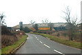
2
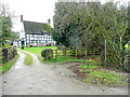
Pool Farm, Colethrop
Plenty of black-and-white in this part of Gloucestershire.
Image: © Jonathan Billinger
Taken: 21 Dec 2011
0.18 miles
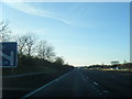
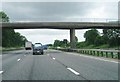
3
Stroud District : M5 Motorway
The M5 Motorway between Junction 12 and Junction 11A (Brockworth Interchange).
Image: © Lewis Clarke
Taken: 30 Sep 2018
0.20 miles
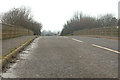
4
Footpath bridge near Pool Farm from M5 south
Image: © John Firth
Taken: 8 Jun 2014
0.21 miles
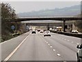
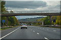
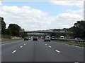
8
Two bridges over M5
The first bridge carries a footpath, the second is a railway bridge for the Bristol to Gloucester line.
Image: © David Smith
Taken: 16 Oct 2012
0.22 miles
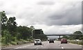
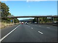
10
Bridge over M5 motorway near Colethrop Farm, Hardwicke, Glos
Image: © Andy F
Taken: 29 Jan 2010
0.25 miles