IMAGES TAKEN NEAR TO
Longney Road, GLOUCESTER, GL2 3SQ
Introduction
This page details the photographs taken nearby to Longney Road, GL2 3SQ by members of the Geograph project.
The Geograph project started in 2005 with the aim of publishing, organising and preserving representative images for every square kilometre of Great Britain, Ireland and the Isle of Man.

There are currently over 7.5m images from over14,400 individuals and you can help contribute to the project by visiting https://www.geograph.org.uk
Image Map
Images are licensed for reuse under creativecommons.org/licenses/by-sa/2.0
Notes
- Clicking on the map will re-center to the selected point.
- The higher the marker number, the further away the image location is from the centre of the postcode.
Image Listing (3 Images Found)
Images are licensed for reuse under creativecommons.org/licenses/by-sa/2.0
Image
Details
Distance
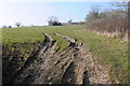
1
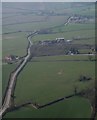
Grove End from the air
The road from Sellars Bridge to Hardwicke winds past Grove End Wood, with Grove End Farm on the left.
Image: © Derek Harper
Taken: 21 Mar 2009
0.07 miles
2
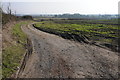
Farm track, Longney
This farm track, with no right of way, provides access to farmland at Longney.
Image: © Philip Halling
Taken: 2 Mar 2013
0.15 miles