IMAGES TAKEN NEAR TO
Booth Way, GLOUCESTER, GL2 2JL
Introduction
This page details the photographs taken nearby to Booth Way, GL2 2JL by members of the Geograph project.
The Geograph project started in 2005 with the aim of publishing, organising and preserving representative images for every square kilometre of Great Britain, Ireland and the Isle of Man.

There are currently over 7.5m images from over14,400 individuals and you can help contribute to the project by visiting https://www.geograph.org.uk
Image Map
Images are licensed for reuse under creativecommons.org/licenses/by-sa/2.0
Notes
- Clicking on the map will re-center to the selected point.
- The higher the marker number, the further away the image location is from the centre of the postcode.
Image Listing (2 Images Found)
Images are licensed for reuse under creativecommons.org/licenses/by-sa/2.0
Image
Details
Distance
1
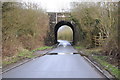
Railway bridge near Naas Crossing
Country road passing under a railway bridge carrying the Gloucester to Bristol railway line.
Image: © Philip Halling
Taken: 26 Jan 2013
0.22 miles
2
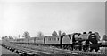
Paignton - Newcastle express at Naas Crossing, near Haresfield 1949
View SE, towards Bristol etc., also Swindon on the GWR - see various other railway scenes along this stretch south of Gloucester. The locomotive on this Summer Saturday relief is LMS Hughes/Fowler 5P4F 'Crab' 2-6-0 No. 42897 (built 1930, withdrawn 4/64).
Image: © Ben Brooksbank
Taken: 13 Aug 1949
0.23 miles