IMAGES TAKEN NEAR TO
Woodvale Kingsway, GLOUCESTER, GL2 2BU
Introduction
This page details the photographs taken nearby to Woodvale Kingsway, GL2 2BU by members of the Geograph project.
The Geograph project started in 2005 with the aim of publishing, organising and preserving representative images for every square kilometre of Great Britain, Ireland and the Isle of Man.

There are currently over 7.5m images from over14,400 individuals and you can help contribute to the project by visiting https://www.geograph.org.uk
Image Map
Images are licensed for reuse under creativecommons.org/licenses/by-sa/2.0
Notes
- Clicking on the map will re-center to the selected point.
- The higher the marker number, the further away the image location is from the centre of the postcode.
Image Listing (6 Images Found)
Images are licensed for reuse under creativecommons.org/licenses/by-sa/2.0
Image
Details
Distance
1
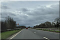
On the A430 near Quedgeley, heading south
Image: © Rob Purvis
Taken: 4 Feb 2024
0.14 miles
2
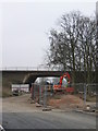
Bus access under A38 Southern Connector Quedgeley
This old farm access will be the main bus access to the new "Quedgeley Urban Village" on the RAF Quedgeley site. A large village at well over 1000 houses! View from Quedgeley retail area.
Image: © Peter Watkins
Taken: 3 Feb 2006
0.14 miles
3
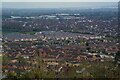
Gloucester : Quedgeley Scenery
Looking across the Quedgeley area.
Image: © Lewis Clarke
Taken: 2 Apr 2023
0.15 miles
4
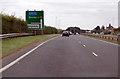
A38 at Quedgeley
Junction to Kingsway ahead.
Image: © J.Hannan-Briggs
Taken: 30 Jul 2014
0.17 miles
5
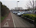
Segregated pavement and cycle path into the Quedgeley District Centre, Quedgeley
From the east side of the B4008 Bristol Road. One of the businesses in the distance is Domino's Pizza.
Image: © Jaggery
Taken: 22 Jan 2017
0.22 miles
6
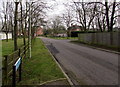
Highliffe Drive, Quedgeley
On the east side of the B4008 Bristol Road.
Image: © Jaggery
Taken: 22 Jan 2017
0.24 miles