IMAGES TAKEN NEAR TO
Saylittle Mews, GLOUCESTER, GL2 0XG
Introduction
This page details the photographs taken nearby to Saylittle Mews, GL2 0XG by members of the Geograph project.
The Geograph project started in 2005 with the aim of publishing, organising and preserving representative images for every square kilometre of Great Britain, Ireland and the Isle of Man.

There are currently over 7.5m images from over14,400 individuals and you can help contribute to the project by visiting https://www.geograph.org.uk
Image Map
Images are licensed for reuse under creativecommons.org/licenses/by-sa/2.0
Notes
- Clicking on the map will re-center to the selected point.
- The higher the marker number, the further away the image location is from the centre of the postcode.
Image Listing (15 Images Found)
Images are licensed for reuse under creativecommons.org/licenses/by-sa/2.0
Image
Details
Distance
1
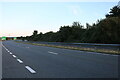
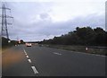
The A40, Longlevens
Approaching the end of the Gloucester Bypass
Image: © David Howard
Taken: 3 Jul 2022
0.03 miles
2
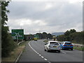
A40 Gloucester Bypass
The second bypass of Gloucester to the north. Gloucester appears to have a rather complex road system.
Image: © Richard Webb
Taken: 31 Aug 2022
0.03 miles
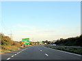
3
A40 Dual Carriageway
This is the section of the road on the north east side of Gloucester. The roundabout in the distance is where it intersects with the B4063.
Image: © Nigel Mykura
Taken: 30 Sep 2012
0.05 miles
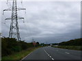
6
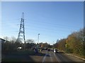
B4063 approaching Gloucester ring road
Just north-east of a large roundabout where the A40 from Cheltenham meets the ring road; the skyline is dominated by the pylon; an important link in the electricity grid follows the ring road for some distance
Image: © David Smith
Taken: 25 Nov 2016
0.19 miles
7
Path and cycle track near busy junction
Approaching the roundabout at the junction of the B4063 and the A40
Image: © Clint Mann
Taken: 1 Apr 2016
0.20 miles

9

B4063 Cheltenham Road westwards at Longlevens
Image: © Roy Hughes
Taken: 2 Jun 2022
0.22 miles
10
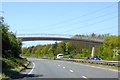
Footbridge from Longlevens to Innsworth
The alternative route for pedestrians is via the road bridge about 500m west
Image: © David Smith
Taken: 22 Apr 2015
0.23 miles