IMAGES TAKEN NEAR TO
Pickwick Close, GLOUCESTER, GL2 0PP
Introduction
This page details the photographs taken nearby to Pickwick Close, GL2 0PP by members of the Geograph project.
The Geograph project started in 2005 with the aim of publishing, organising and preserving representative images for every square kilometre of Great Britain, Ireland and the Isle of Man.

There are currently over 7.5m images from over14,400 individuals and you can help contribute to the project by visiting https://www.geograph.org.uk
Image Map
Images are licensed for reuse under creativecommons.org/licenses/by-sa/2.0
Notes
- Clicking on the map will re-center to the selected point.
- The higher the marker number, the further away the image location is from the centre of the postcode.
Image Listing (7 Images Found)
Images are licensed for reuse under creativecommons.org/licenses/by-sa/2.0
Image
Details
Distance
2
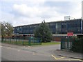
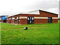
Sir Thomas Rich's School, Gloucester
Founded in 1668 as the Blue Coat Hospital for boys from the will of Sir Thomas Rich, it changed name to Sir Thomas Rich's in 1882. The school moved to this current site in Elmbridge in 1964 from its previous site in Barton Street (Image) and today has been awarded Beacon school status. For more information see http://www.school-portal.co.uk/GroupHomepage.asp?GroupID=14257
Image: © David Stowell
Taken: 18 Sep 2005
0.12 miles
3
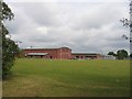
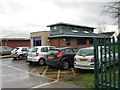
Playing Fields, Sir Thomas Rich's School
The playing fields and sport hall at the rear of the school in Oxlease, Gloucester.
Image: © David Stowell
Taken: 18 Sep 2005
0.12 miles
7
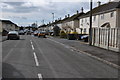
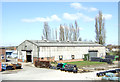
Elmleaze, Elmbridge
Road on a housing estate at Elmbridge in the suburbs of Gloucester.
Image: © Philip Halling
Taken: 26 Feb 2011
0.24 miles