IMAGES TAKEN NEAR TO
Wellsprings Road, GLOUCESTER, GL2 0NL
Introduction
This page details the photographs taken nearby to Wellsprings Road, GL2 0NL by members of the Geograph project.
The Geograph project started in 2005 with the aim of publishing, organising and preserving representative images for every square kilometre of Great Britain, Ireland and the Isle of Man.

There are currently over 7.5m images from over14,400 individuals and you can help contribute to the project by visiting https://www.geograph.org.uk
Image Map
Images are licensed for reuse under creativecommons.org/licenses/by-sa/2.0
Notes
- Clicking on the map will re-center to the selected point.
- The higher the marker number, the further away the image location is from the centre of the postcode.
Image Listing (5 Images Found)
Images are licensed for reuse under creativecommons.org/licenses/by-sa/2.0
Image
Details
Distance
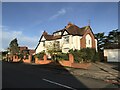
1
Rydal Road meets Oxstalls Lane
A 1930's suburb of Gloucester.
Image: © Jonathan Billinger
Taken: 22 Oct 2010
0.10 miles
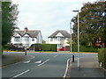
2
Oxstalls Lane, Longlevens
Quiet suburbia to the north of Gloucester city centre.
Image: © Jonathan Billinger
Taken: 22 Oct 2010
0.12 miles
3
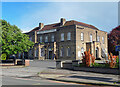
Former pub, Longlevens
The Double Gloucester, big brick pub by Dancey & Meredith, 1938.
It seems to have since closed, in 2016, and the site is to be, or has been, cleared for housing.
Image: © Stephen Richards
Taken: 19 May 2015
0.16 miles
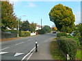
4

B4063 Cheltenham Road westwards approaching Oxstalls Road junction
Image: © Roy Hughes
Taken: 2 Jun 2022
0.16 miles