IMAGES TAKEN NEAR TO
Nine Elms Road, GLOUCESTER, GL2 0HA
Introduction
This page details the photographs taken nearby to Nine Elms Road, GL2 0HA by members of the Geograph project.
The Geograph project started in 2005 with the aim of publishing, organising and preserving representative images for every square kilometre of Great Britain, Ireland and the Isle of Man.

There are currently over 7.5m images from over14,400 individuals and you can help contribute to the project by visiting https://www.geograph.org.uk
Image Map
Images are licensed for reuse under creativecommons.org/licenses/by-sa/2.0
Notes
- Clicking on the map will re-center to the selected point.
- The higher the marker number, the further away the image location is from the centre of the postcode.
Image Listing (19 Images Found)
Images are licensed for reuse under creativecommons.org/licenses/by-sa/2.0
Image
Details
Distance
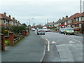
1

Nine Elms Road
With Orchard Road leading off to the right. Not much evidence of an orchard, and I expect the elms all died of Dutch elm disease a while back.
Image: © HelenK
Taken: 11 Jul 2016
0.01 miles
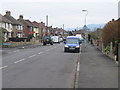
2
Orchard Road
The subject of Leo Sayer's 1983 UK Hit?
It might as well be.
Image: © Jonathan Billinger
Taken: 10 Dec 2010
0.05 miles

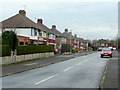
6
Nine Elms Road
Older housing in a suburb of Gloucester.
Image: © Jonathan Billinger
Taken: 10 Dec 2010
0.12 miles
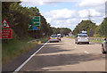
7

B4063 Cheltenham Road westwards at Longlevens
Image: © Roy Hughes
Taken: 2 Jun 2022
0.12 miles
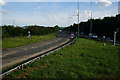
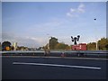
9
A40 approaching Elmbridge Court roundabout
The A40 splits here towards Ross or Cheltenham.
Image: © J.Hannan-Briggs
Taken: 27 Jul 2014
0.15 miles