IMAGES TAKEN NEAR TO
Hardwick Bank Road, TEWKESBURY, GL20 8RP
Introduction
This page details the photographs taken nearby to Hardwick Bank Road, GL20 8RP by members of the Geograph project.
The Geograph project started in 2005 with the aim of publishing, organising and preserving representative images for every square kilometre of Great Britain, Ireland and the Isle of Man.

There are currently over 7.5m images from over14,400 individuals and you can help contribute to the project by visiting https://www.geograph.org.uk
Image Map
Images are licensed for reuse under creativecommons.org/licenses/by-sa/2.0
Notes
- Clicking on the map will re-center to the selected point.
- The higher the marker number, the further away the image location is from the centre of the postcode.
Image Listing (7 Images Found)
Images are licensed for reuse under creativecommons.org/licenses/by-sa/2.0
Image
Details
Distance
1
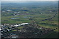
Aerial view of Northway
The housing estate at Northway can be seen in the near distance with the M5 motorway passing by, on the left are some of the industrial units that have mushroomed around junction 9 of the motorway. The village of Twyning, which is quite a large village but looks insignificant is in the centre. In the distance the Malvern Hills can be seen on the left and further away near the horizon to the right of centre are the Abberley Hills.
Image: © Philip Halling
Taken: 12 Apr 2008
0.03 miles
2
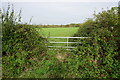
Fields to the north of Northway
The fields are currently separated from the housing development by quite a thick hedge.
Image: © Bill Boaden
Taken: 31 Oct 2014
0.03 miles
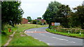
3
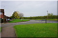
The northern edge of Northway
Hardwick Bank Road currently marks the north edge of the housing development, but you wonder how long it will be before it crosses the road to the fields the other side.
Image: © Bill Boaden
Taken: 31 Oct 2014
0.13 miles
4
Northway
The shopping centre at Northway, a large estate to the east of Tewkesbury. Looking east by the Northway Arms.
Image: © Dave Bushell
Taken: 5 Oct 2005
0.16 miles
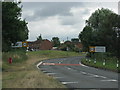
6
Northway city limits
Approaching from the direction of Bredon.
Image: © Jonathan Billinger
Taken: 21 Aug 2012
0.22 miles
7
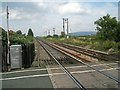
Level crossing, Northway
Looking North along the Bristol to Birmingham main line. A rapidly disappearing Virgin Voyager can just be seen in the distance, heading North. The railway line is the boundary between Northway (housing) estate, on the left and farmland, on the right.
Image: © Jennifer Luther Thomas
Taken: 20 Sep 2006
0.23 miles