IMAGES TAKEN NEAR TO
Ashchurch, TEWKESBURY, GL20 8JX
Introduction
This page details the photographs taken nearby to Ashchurch, GL20 8JX by members of the Geograph project.
The Geograph project started in 2005 with the aim of publishing, organising and preserving representative images for every square kilometre of Great Britain, Ireland and the Isle of Man.

There are currently over 7.5m images from over14,400 individuals and you can help contribute to the project by visiting https://www.geograph.org.uk
Image Map
Images are licensed for reuse under creativecommons.org/licenses/by-sa/2.0
Notes
- Clicking on the map will re-center to the selected point.
- The higher the marker number, the further away the image location is from the centre of the postcode.
Image Listing (265 Images Found)
Images are licensed for reuse under creativecommons.org/licenses/by-sa/2.0
Image
Details
Distance
1
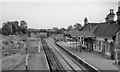
Ashchurch station
A dismal view southward from the footbridge of the ?deserted station, now bereft of its Junction status. Weeds grow where Evesham line trains used to join on the left, leaving just one line that goes into the MoD Depot. The A438 roadbridge has now been widened. The splendid Midland Railway canopy and station buildings have only a year or two before demolition.
Image: © Ben Brooksbank
Taken: 23 Aug 1969
0.02 miles

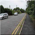
3
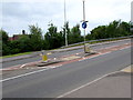
Pedestrian refuge in the A46, Ashchurch
The refuge lets walkers cross half a road width at a time when traffic is busy on the A46.
Image: © Jaggery
Taken: 29 Jul 2017
0.03 miles
4
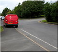
Royal Mail van, Ashchurch
The red Peugeot van is parked here http://www.geograph.org.uk/photo/5484671 while its driver delivers letters and small parcels
on a Saturday morning in July 2017. The van's identifier TK8 shows that it is based in Tewkesbury.
Image: © Jaggery
Taken: 29 Jul 2017
0.03 miles
5
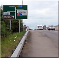
A46 directions sign, Ashchurch
Facing westbound traffic on the A46. The station is Ashchurch for Tewkesbury railway station.
Image: © Jaggery
Taken: 29 Jul 2017
0.03 miles
6
Western end of a side road, Ashchurch
Parallel with the south side of the A46, this dead-end side road gives access to the village hall, http://www.geograph.org.uk/photo/5484652
village school and War Memorial behind the camera. The western end of the road is 85 metres ahead.
Image: © Jaggery
Taken: 29 Jul 2017
0.04 miles
7
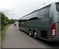
Brent Thomas coach in Ashchurch, Gloucestershire
The three-axle coach is travelling east on the A46.
Brent Thomas Coaches are based in Tonypandy in the Rhondda, South Wales.
Image: © Jaggery
Taken: 29 Jul 2017
0.04 miles
8
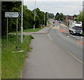
Ashchurch Primary School and Village Hall direction sign
Facing eastbound traffic on the A46 in Ashchurch, Gloucestershire.
Image: © Jaggery
Taken: 29 Jul 2017
0.04 miles
9
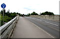
East across the A46 railway bridge, Ashchurch
The bridge carries the A46 over railway lines 100 metres south of Ashchurch for Tewkesbury railway station.
Image: © Jaggery
Taken: 29 Jul 2017
0.04 miles
10
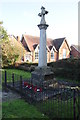
Ashchurch War Memorial
Ashchurch war memorial with the village school in the background.
Image: © Philip Halling
Taken: 1 Feb 2014
0.05 miles