IMAGES TAKEN NEAR TO
Cheltenham Road, TEWKESBURY, GL20 8HW
Introduction
This page details the photographs taken nearby to Cheltenham Road, GL20 8HW by members of the Geograph project.
The Geograph project started in 2005 with the aim of publishing, organising and preserving representative images for every square kilometre of Great Britain, Ireland and the Isle of Man.

There are currently over 7.5m images from over14,400 individuals and you can help contribute to the project by visiting https://www.geograph.org.uk
Image Map
Images are licensed for reuse under creativecommons.org/licenses/by-sa/2.0
Notes
- Clicking on the map will re-center to the selected point.
- The higher the marker number, the further away the image location is from the centre of the postcode.
Image Listing (10 Images Found)
Images are licensed for reuse under creativecommons.org/licenses/by-sa/2.0
Image
Details
Distance
1
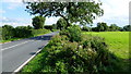
Pasture by the B4079
Looking south along the Cheltenham Road.
Image: © Jonathan Billinger
Taken: 21 Aug 2012
0.11 miles
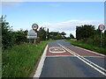
2
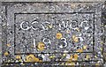
Old Bridge Marker by the B4079
Bridge Marker set in the west parapet of the bridge over Carrant Brook, on the B4079. Inscribed G C C W C C / 1937. On the boundary of Kemerton parish, Worcestershire and Ashchurch Rural parish, Gloucestershire. This is considered to mark the division of responsibility for maintaining the bridge between the two county councils, rather than the county boundary, so GCC and WCC rather than Gloucestershire and Worcestershire.
Milestone Society National ID: WO_KEMASH01br
Image: © M Bardell
Taken: 12 Apr 2018
0.18 miles
3
Sharp bend in the B4079 near Aston on Carrant
Towards Kinsham.
Image: © JThomas
Taken: 13 Aug 2021
0.18 miles
5
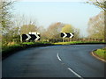
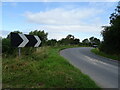
Sharp Right Hand Bend, Double Chevron Near Aston on Carrant
Image: © Roy Hughes
Taken: 29 Nov 2014
0.20 miles
6
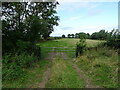
Field entrance off the B4079 near Aston on Carrant
Image: © JThomas
Taken: 13 Aug 2021
0.20 miles
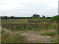
7

Gravel Extraction
Just north of Aston on Carrant (named after the Carrant Brook). Archaeological investigations in the Carrant Brook area have shown the area to have been highly populated in bronze and iron age times. Viewed looking NW along what is supposed to have been the right of way.
Image: © Bob Embleton
Taken: 20 Oct 2005
0.22 miles
8
Crop field and hedgerow near Barn Farm Cottage
Off the B4079.
Image: © JThomas
Taken: 13 Aug 2021
0.24 miles
10
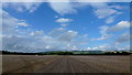
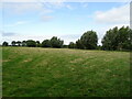
Rape stubble
Looking north along the footpath line with Bredon Hill filling the horizon.
Image: © Jonathan Billinger
Taken: 21 Aug 2012
0.24 miles