IMAGES TAKEN NEAR TO
Franklin Road, TEWKESBURY, GL20 8FE
Introduction
This page details the photographs taken nearby to Franklin Road, GL20 8FE by members of the Geograph project.
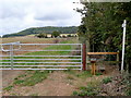
The Geograph project started in 2005 with the aim of publishing, organising and preserving representative images for every square kilometre of Great Britain, Ireland and the Isle of Man.

There are currently over 7.5m images from over14,400 individuals and you can help contribute to the project by visiting https://www.geograph.org.uk
Image Map
Images are licensed for reuse under creativecommons.org/licenses/by-sa/2.0
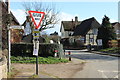
Notes
- Clicking on the map will re-center to the selected point.
- The higher the marker number, the further away the image location is from the centre of the postcode.
Image Listing (31 Images Found)
Images are licensed for reuse under creativecommons.org/licenses/by-sa/2.0
Image
Details
Distance
1
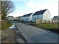
New houses in Alderton
Since I last was in Alderton a large number of houses have been built on the western edge of the village. Unfortunately I don't have a picture of the farmland before it was built on.
Image: © Philip Halling
Taken: 4 Feb 2017
0.03 miles
2
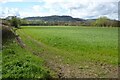
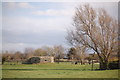
View to Oxenton Hill
View to Oxenton Hill across farmland at Alderton. The Winchcombe Way follows the footpath beside the hedgerow on the left.
Image: © Philip Halling
Taken: 1 Apr 2024
0.06 miles
3
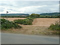
Footpath south-west
From the Beckford/Alderton road to the B4077 at The Hobnails pub.
Image: © Jonathan Billinger
Taken: 30 Sep 2009
0.07 miles
4
Footpath to Washbourne Hill
Complete with brand-spanking new stile!
Image: © Jonathan Billinger
Taken: 30 Sep 2009
0.09 miles
5
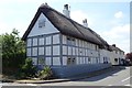
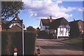
Timber-framed cottage in Alderton
The colour of this thatched timber-framed house is a little unorthodox, black and white is widespread, this cottage in Alderton is grey and white.
Image: © Philip Halling
Taken: 6 Jul 2018
0.11 miles
6
Pillbox near Alderton
A hexagonal FW3 type 22 pillbox camouflaged with local Cotswold stone. A number of similar pillboxes exist in the Alderton and Winchcombe area.
Image: © Roger Davies
Taken: 3 Mar 2012
0.12 miles
7
Timber-frame thatched cottage
Timber-frame thatched cottage in the village of Alderton. The cottage is Grade II listed and is thought to date from the late 17th or early 18th century.
Image: © Philip Halling
Taken: 1 Apr 2024
0.13 miles
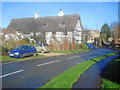
8
Alderton
The western end of the village with The Gardener's Arms.
Image: © Richard Webb
Taken: 10 Nov 2002
0.13 miles
9
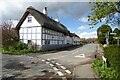
Thatched house on Willow Bank Road
Looking north to the junction with Beckford Road. One of several timber-framed thatched buildings in the village, which retains a lot of character, possibly because it is a little off the beaten track.
Image: © Trevor Rickard
Taken: 27 Nov 2009
0.13 miles