IMAGES TAKEN NEAR TO
Rosefield Crescent, TEWKESBURY, GL20 8EQ
Introduction
This page details the photographs taken nearby to Rosefield Crescent, GL20 8EQ by members of the Geograph project.
The Geograph project started in 2005 with the aim of publishing, organising and preserving representative images for every square kilometre of Great Britain, Ireland and the Isle of Man.

There are currently over 7.5m images from over14,400 individuals and you can help contribute to the project by visiting https://www.geograph.org.uk
Image Map
Images are licensed for reuse under creativecommons.org/licenses/by-sa/2.0
Notes
- Clicking on the map will re-center to the selected point.
- The higher the marker number, the further away the image location is from the centre of the postcode.
Image Listing (25 Images Found)
Images are licensed for reuse under creativecommons.org/licenses/by-sa/2.0
Image
Details
Distance
1
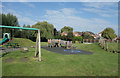
Derek Graham Memorial Gardens
A small suburban park largely taken up with children's play equipment.
Image: © Des Blenkinsopp
Taken: 25 Aug 2019
0.08 miles
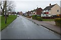
2
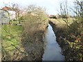
Tirle Brook with houses to the left
The houses on the left are on Tirle Bank Way, part of the Newtown housing estate. The road the houses are on takes its name from Tirle Brook which is pictured here.
Image: © Philip Halling
Taken: 13 Dec 2016
0.09 miles
3
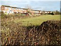
Houses on Tirle Bank Way
Houses on Tirle Bank Way which back onto Tirle Brook.
Image: © Philip Halling
Taken: 13 Dec 2016
0.10 miles
4
Bridge over Tirle Brook
Bridge carrying a country road to Walton Cardiff over Tirle Brook on the edge of Tewkesbury.
Image: © Philip Halling
Taken: 13 Dec 2016
0.10 miles
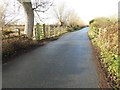
5
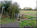
Footpath west from the lane to Walton Cardiff
The kissing gate is unneccessary with current land-use.
Image: © Jonathan Billinger
Taken: 13 Nov 2009
0.12 miles
6
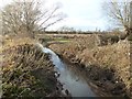
Tirle Brook
Compare this same view of Tirle Brook to this one taking in March 2008 Image
Image: © Philip Halling
Taken: 13 Dec 2016
0.12 miles
7
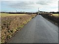
Road to Walton Cardiff
Country road to Walton Cardiff, viewed from where the road crosses Tirle Brook.
Image: © Philip Halling
Taken: 13 Dec 2016
0.13 miles
8
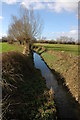
Tirle Brook, Tewkesbury
Tirle Brook to the east of Tewkesbury. The low lying land here regularly floods to a considerable depth.
Image: © Philip Halling
Taken: 1 Mar 2008
0.14 miles
9
Knights Way, Newton
Knights Way in Newton, a late 1950s/earlier 1960s housing development beside the Ashchurch Road in Tewkesbury.
Image: © Philip Halling
Taken: 10 Jan 2022
0.15 miles
10
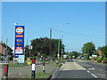
A438 Ashchurch Road Tewkesbury Near Pyke Road
Image: © Roy Hughes
Taken: 25 May 2020
0.16 miles