IMAGES TAKEN NEAR TO
Mitton Way, TEWKESBURY, GL20 8BJ
Introduction
This page details the photographs taken nearby to Mitton Way, GL20 8BJ by members of the Geograph project.
The Geograph project started in 2005 with the aim of publishing, organising and preserving representative images for every square kilometre of Great Britain, Ireland and the Isle of Man.

There are currently over 7.5m images from over14,400 individuals and you can help contribute to the project by visiting https://www.geograph.org.uk
Image Map
Images are licensed for reuse under creativecommons.org/licenses/by-sa/2.0
Notes
- Clicking on the map will re-center to the selected point.
- The higher the marker number, the further away the image location is from the centre of the postcode.
Image Listing (34 Images Found)
Images are licensed for reuse under creativecommons.org/licenses/by-sa/2.0
Image
Details
Distance
1
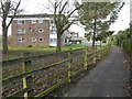
Flats on Mitton
Flats on the Mitton estate in Tewkesbury.
Image: © Philip Halling
Taken: 27 Dec 2016
0.00 miles
2
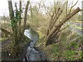
Carrant Brook
Carrant Brook is a small tributary of the River Avon, its catchment area being land to the south of Bredon Hill. The brook for part of its course is the county boundary between Gloucestershire and Worcestershire.
Image: © Philip Halling
Taken: 27 Dec 2016
0.05 miles
3
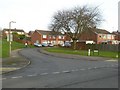
Brookside, Mitton
Brookside on Mitton estate in Tewkesbury. The road is so named because of it proximity to Carrant Brook which flows nearby.
Image: © Philip Halling
Taken: 27 Dec 2016
0.06 miles
4
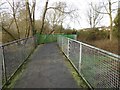
Footbridge crossing Carrant Brook
This footbridge links the residential housing estate Mitton with the mainly industrial south side of Carrant Brook.
Image: © Philip Halling
Taken: 27 Dec 2016
0.07 miles
5

Tewkesbury from the air
The town centre of Tewkesbury is to the left, housing developments of the 1960s can be seen in this picture, with Newtown in the foreground and Mitton beyond. The River Avon can be seen flowing from right to left and the River Severn is to the top left. Mythe Water Treatment Works can also be seen beside the River Severn, this is the treatment plant which had to be closed for a few days in July 2007 when it became flooded, leaving much of Gloucestershire without water.
Image: © Philip Halling
Taken: 12 Apr 2008
0.08 miles
6
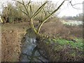
Carrant Brook
Carrant Brook is a small tributary of the River Avon, its catchment area being land to the south of Bredon Hill. The brook for part of its course is the county boundary between Gloucestershire and Worcestershire.
Image: © Philip Halling
Taken: 27 Dec 2016
0.09 miles
8

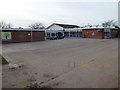
Pipeline works on the edge of Tewkesbury
There was nothing to say which utility company was doing this work. The path links Mitton and Newtown.
Image: © Bill Boaden
Taken: 31 Oct 2014
0.10 miles
9
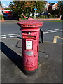
An adopted postbox in Mitton, Tewkesbury
The postbox is on the corner of Mitton Way and Carrant Road.
A metal plate on the postbox shows that it has been adopted
by pupils of Mitton Manor Primary School. I don't know what
the adoption involves, but the box was looking in need of some
attention at the October 2012 date of this view.
Image: © Jaggery
Taken: 14 Oct 2012
0.13 miles
10
Toll House, Tewkesbury
On the Road from Evesham (and these days from the M5)
Image: © Bob Embleton
Taken: 19 Apr 2005
0.13 miles