IMAGES TAKEN NEAR TO
Orchard Close, TEWKESBURY, GL20 7NH
Introduction
This page details the photographs taken nearby to Orchard Close, GL20 7NH by members of the Geograph project.
The Geograph project started in 2005 with the aim of publishing, organising and preserving representative images for every square kilometre of Great Britain, Ireland and the Isle of Man.

There are currently over 7.5m images from over14,400 individuals and you can help contribute to the project by visiting https://www.geograph.org.uk
Image Map
Images are licensed for reuse under creativecommons.org/licenses/by-sa/2.0
Notes
- Clicking on the map will re-center to the selected point.
- The higher the marker number, the further away the image location is from the centre of the postcode.
Image Listing (9 Images Found)
Images are licensed for reuse under creativecommons.org/licenses/by-sa/2.0
Image
Details
Distance
3

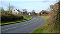
Path leaves the houses at the bend in Blenheim Drive, Bredon
Image: © Liz Stone
Taken: 27 Aug 2012
0.12 miles
4
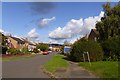
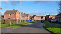
Queensmead, Bredon
A small housing estate in the Waterloo area of Bredon
Image: © David Smith
Taken: 8 Oct 2016
0.13 miles
5
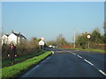
Cheltenham Road, approaching Bredon
The B4079 heading north-west.
Image: © Jonathan Billinger
Taken: 4 Dec 2012
0.14 miles
6

Stile with good steps behind houses, Bredon
Image: © Liz Stone
Taken: 27 Aug 2012
0.20 miles
7
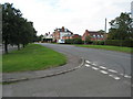
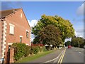
Queensmead, Bredon
Older-style housing on the eastern edge of the village.
Image: © Jonathan Billinger
Taken: 4 Dec 2012
0.22 miles
9
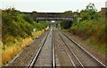
Agricultural bridge over the line at Bredon
Image: © Steve Daniels
Taken: 2 Sep 2009
0.23 miles